Tag Archives: science

Semester@Skidaway brings undergrads to UGA Skidaway Institute

The fall semester 2022 marks a major milestone in the growth of the University of Georgia Skidaway Institute’s education mission beyond its historical role as a research laboratory. The Semester@Skidaway domestic field study program is a significant part of the UGA Department of Marine Sciences new undergraduate ocean sciences major. A small cohort of ocean sciences majors are spending the entire fall semester in residence at UGA Skidaway Institute taking classes and learning how to conduct marine research.

Assistant professor Sara Rivero-Calle teaches one of the undergraduate courses with students at Skidaway Institute and in Athens, as seen in the monitor.

The Semester@Skidaway serves, essentially, as a capstone type experience for students before they graduate,” said Semester@Skidaway program director Clifton Buck. “The students have the opportunity to take a number of courses that are taught here, but also they have the chance to take courses that are much more immersive and hands on.”

The research-based activities include field surveys, collecting samples from the environment, returning them back to the laboratory and analyzing them for chemical, biological and physical parameters.

“They make a scientific journey from actually being out in the field and then into the laboratory, to analyze the data and think about it critically” Buck said.

Semester@Skidaway students (l-r) Taylor English, Dillon Doomstorm, Ava Meier and Sarah Belcher

The students take five three-credit courses that cover a wide range of marine science topics including data analysis techniques and marine science field methods. They also study the unique South Atlantic Bight system located off our coast under the instruction of associate professor Catherine Edwards. A highlight of the semester will be a cruise aboard the Research Vessel Savannah. Professor Jay Brandes teaches a course that focuses on the planning and preparation needed for a successful research cruise.

“They’ll go on a two-day cruise just offshore and collect samples, apply some of the things they’ve learned in the laboratory class and bring those samples back and work with them,” Buck said. “And so again, they will take it from the planning stage through the execution, through the sample analysis and data interpretation.”

The fall 2022 group consists of just a handful of students. As the ocean sciences major grows, Buck expects later cohorts to include about 24 students.

“The Semester @ Skidaway program brings highly motivated ocean science majors to the Skidaway campus to experience hands-on and research-based instruction,” UGA Skidaway Institute Director Clark Alexander said. “This influx of young, enthusiastic students enhances the programs at Skidaway by their presence, and we are excited to be teaching tomorrow’s scientists and informed citizens.”

Cutting edge survey charts Georgia’s artificial reefs

– Beginning in 1970, the Georgia Department of Natural Resources built a series of artificial reefs to provide habitat for marine life. However, until recently, there were gaps in some of the key information about those reefs, such as the precise locations of the materials placed on the bottom and water depth over the materials. Now, researchers at the University of Georgia Skidaway Institute of Oceanography are using cutting-edge bathymetric side-scan sonar and high-resolution geographic positioning systems (GPS) to provide coastal managers and fishermen a detailed picture of the location and condition of reef materials.

Georgia’s shelf is relatively shallow and extends approximately 80 miles offshore before dropping into the deep ocean. Most of the shelf bottom consists of shifting sand, which does not provide the kind of conditions to develop and support diverse reef communities.

“Much of the continental shelf is like a vast sandy desert,” UGA Skidaway Institute scientist Clark Alexander said. “So, what we need is more hard substrate, because that is really the most important thing for establishing stable live-bottom communities.”

A battle tank is pushed into the ocean to form part of an artificial reef. Photo credit: Georgia DNR.

Over the past 50 years, the state has placed hard-surface materials in 18 sites, each about 15 square kilometers in size. Eight of the sites are located along the coast approximately 10 miles off shore and another eight approximately 25 miles off shore. There are also two “beach reefs” that are closer to shore and accessible to fishermen with smaller boats. The reefs are made up of a wide range of materials, including old ships, battle tanks, pieces from the original Talmadge Bridge, retired subway cars from New York City, concrete pipes and pilings, and purpose-built, concrete tetrapods.

“The materials that were placed on the bottom in the 1970s and 1980s were sunk in place or deployed from barges using Loran-C, a radio-based navigation system that was significantly less accurate than current GPS, or dropped from Army helicopters, so their precise locations are not always exactly known,” Alexander said. “In addition, we have had a number of hurricanes and winter storms come through or offshore Georgia, and we don’t know whether some of the material has been moved from its original location.”

Alexander proposed a program to survey the reefs and develop a more accurate set of data on their locations and characteristics, which was subsequently funded through the Georgia Coastal Management Program, administered by the Georgia Department of Natural Resources Coastal Resources Division.

Marine life attracted to one of Georgia’s artificial reefs. Photo credit: Georgia DNR.

“Our goals were to document the status of what is on the bottom, and to give more precise locations for the objects we identify,” Alexander said. “We used real-time kinematic GPS, so we know within a few centimeters where things are on the bottom.”

Alexander’s team began field work in 2018 and continued into 2021, using the 28-foot RV Jack Blanton. They spent an average of six days surveying each reef. They started with the beach reefs to work out any kinks in the planned survey approach and then moved on to the reefs 10 miles off shore. Along with high-resolution GPS, the team used an interferometric side-scan sonar that gives the depth and co-registered side-scan sonar imagery that provides images of the seafloor and objects sitting on it.

“Based on an object’s general location, and existing location data, we were able to make some good guesses as to ‘Oh, that must be a certain barge or ship’ and so on,” he said. “And we found a few objects that were not on existing maps and several others that had fragmented into several pieces since being placed.”

Another important parameter the team measured was the amount of clearance between the various structures and the ocean surface.

“You don’t want to have to worry about anything you put down being a hazard to navigation,” Alexander said. “Ten kilometers off shore, you are in about 10 meters of water or so, about 30 feet. So, if one of these sunken vessels was sticking up a significant height above the bottom, that is something you need to know.”

Alexander and DNR are making plans to survey the eight reefs that are about 25 miles off shore. They present a greater challenge than the reefs closer to shore. The longer distance means greater transit time and less time on-station actually conducting the survey. The team would also be constrained by the weather. Conditions must be very good and forecast to remain calm throughout both the transits and survey.

“Because when you are that far offshore, you are at the mercy of sea conditions, which can change quickly” Alexander said.

The data Alexander’s team collected is now being added to the DNR’s marine artificial reef fishing website. These new data products enhance the data available to anglers, and now allows users to zoom in to the individual features, see what they look like, and how they are distributed in relation to other features on the bottom. The data collected by the project can be found on the DNR’s artificial reef website: https://coastalgadnr.org/HERU/offshore

UGA Skidaway Institute’s Edwards granted tenure

The University of Georgia has granted tenure to UGA Skidaway Institute of Oceanography / Department of Marine Sciences scientist Catherine Edwards. Edwards was also promoted from assistant professor to associate professor, effective Aug. 1.

OLYMPUS DIGITAL CAMERAEdwards is a physical oceanographer, with broad interdisciplinary interests in marine sciences and engineering. She earned a B.S. in physics with highest honors from the University of North Carolina at Chapel Hill, and worked as an ocean modeler at the U.S. Naval Research Laboratory before earning her Ph.D. in physical oceanography from the University of North Carolina at Chapel Hill. She joined Skidaway Institute in 2010.

Edwards’ research focuses on answering fundamental questions in coastal oceanography and fisheries sciences with autonomous underwater vehicles (AUVs). Using AUVs, also called gliders, she and her team are developing novel ways to optimize their use with engineering principles and real-time data streams from models and observations.

While at UGA Skidaway Institute, Edwards has been awarded more than $2 million dollars on 12 projects totaling more than $12 million from NOAA/Navy sources, the Gulf of Mexico Research Initiative and four different programs within the National Science Foundation. As the founder of a regional glider observatory, she serves as the lead scientist in a new project that places gliders in the paths of hurricanes to better predict their intensity at landfall. Edwards is a co-primary investigator in a large $5 million observational program studying exchange between the coastal and deep ocean at Cape Hatteras. In an effort funded by NSF’s Smart and Autonomous Systems program, Edwards is also working with researchers from Georgia Tech and Gray’s Reef National Marine Sanctuary to utilize gliders and acoustic tagging to track fish migrations.

Scientific serendipity: Researchers make surprising finding on ocean’s ‘thin layers’

Sometimes scientists start out researching one subject, but along the way, they come across something else even more interesting. This is what happened to University of Georgia Skidaway Institute of Oceanography researcher Adam Greer in the summer of 2016 when Greer was a post-doctoral associate at the University of Southern Mississippi. That fortuitous event resulted in a paper recently published in the journal Limnology and Oceanography with Greer as the lead author.

Adam Greer 1 650pGreer and his fellow researchers were on a cruise in the northern Gulf of Mexico to study the effects of river input on biological processes. They came across a natural phenomenon called a thin layer. These are oceanographic features found all over the world where biomass collects into a narrow portion of the water column–less than five meters thick vertically–and can extend for several kilometers horizontally. They tend to occur in stratified shelf systems.

“Surprisingly, there are few published studies on thin layers in the northern Gulf of Mexico, which is heavily influenced by rivers and highly stratified during the summer,” Greer said. “Thin layers are important because they are trophic hot spots, where life tends to congregate, and predators and prey interact.”

However, Greer said, thin layers are very difficult to analyze because they occur within a restricted portion of the water column, and most conventional ocean sampling equipment will not detect their influence on different organisms.

Greer and his colleagues were better equipped than most to study the thin layer. Rather than laying out a grid and taking a series of water samples, they were equipped with an In Situ Ichthyoplankton Imaging System (ISIIS). This imaging system was towed behind their research vessel and undulated through the water column, producing a live feed of plankton images and oceanographic data. By studying the video, they were able to map the distributions of many different types of organisms in great detail. The thin layer was composed of large chains of phytoplankton called diatoms and gelatinous zooplankton called doliolids.

Thin Layer 2

A crewman launches the ISIIS.

“Although we expected many different organisms to aggregate within the layer, this was not the case,” Greer said. “The only organisms that were concentrated within the layer were gelatinous organisms called doliolids. Other organisms that we expected to see, such as copepods, chaetognaths and shrimp, tended to congregate near the surface just south of the thin layer.”

The researchers determined that the area south of the thin layer was influenced by a surface convergence – two water masses colliding and pushing water downward at a slow rate. They believe that many organisms with active swimming ability, such as shrimps and copepods, could stay within the surface convergence, while more passive swimmers, such as doliolids would follow the trajectory of the thin layer and diatoms.

Thin Layer 1

An image from the In Situ Ichthyoplankton Imaging System passing through the thin layer. The long, slender filaments are chains of diatoms. The larger, oval plankton are doliolids

Greer and his colleagues discovered several other characteristics of the thin layer they had not anticipated. There was a higher concentration of live phytoplankton than expected. As a result, the thin layer also had a high concentration of dissolved oxygen due to the photosynthetic activity. The zooplankton were also aggregated into distinct microhabitats with different oceanographic properties — such as temperature, salinity and light. The microhabitats also contained different types and abundances of food.

“For a lot of these organisms, if you took the average abundance of food it wouldn’t be enough to survive,” Greer said. “So whatever mechanisms there are to create higher abundances of food, they are potentially really important for a number of different organisms.”

The other members of the research team were Adam Boyette, Valerie Cruz, Kemal Cambazoglu, Luciano Chiaverano and Jerry Wiggert, all from the University of Southern Mississippi; Brian Dzwonkowski and Steven Dykstra, from the University of South Alabama; and Christian Briseño‐Avena and Bob Cowen, from Oregon State University.
The paper can be viewed HERE.

Marine scientists map fish habitats

by Alan Flurry

Beyond the barrier islands of coastal Georgia, the continental shelf extends gradually eastward for almost 80 miles to the Gulf Stream. This broad, sandy shelf largely does not provide the firm foundation needed for the development of reef communities to support recreational and commercial fish species including grouper, snapper, black sea bass and amberjack.

“Natural and artificial reef habitats are important to Georgia fisheries because they provide hard, permanent structure on the Georgia shelf, which is dominantly a vast underwater desert of shifting sands,” said Clark Alexander, professor and director of the University of Georgia Skidaway Institute of Oceanography. “The Georgia Department of Natural Resources has invested significantly over the past several years in developing the capacity to map these areas to enhance the management of these reef communities.“

To increase the availability of high-quality hard bottom areas off Georgia, the DNR began an artificial reef-building program in 1971 to deploy materials at various locations across the continental shelf, from 2 to 30 miles offshore. Reef materials include concrete slabs and culverts from road, bridge and building demolition, subway cars, ships, barges, and U.S. Army tanks. Because some of these reefs are far offshore and DNR resources are limited, the status of some of that material has not been examined for decades.

Ossabaw sound 650p sq

A bathymetric survey of Ossabaw Sound.

For the past five years, Alexander has been leading an effort to improve understanding of marine, coastal and estuarine habitats and functions using high-resolution sonar to map state water bottoms, with funding from the DNR Coastal Incentive Grant program. Alexander’s team has amassed critical depth and habitat information for five of Georgia’s sounds (Wassaw, Ossabaw, St. Catherine’s, Doboy and Sapelo), revealing deeply scoured areas where underwater cliffs have formed to create hard substrate where complex ecosystems and biological communities have developed.

“These inshore, hardbottom habitats should enhance biodiversity in the areas near these structures and enhance ecosystems supporting both commercial and recreational species across the continental shelf,” Alexander said.

Alexander is currently leading a new, three-year project mapping important fish habitats in state waters — the newly discovered estuarine habitats, and artificial reef structures within 10 nautical miles of shore – those areas most accessible to recreational anglers, boaters and divers. In addition, his research group is mapping previously unmapped portions of the sounds and tidal rivers deeper than 15 meters to discover the extent of these newly identified estuarine hardbottom habitats.

Skidaway Institute researchers will work with DNR to update the online “Boater’s Guide to Artificial Reefs” with accurate locations and imagery of deployed materials for these reefs. These new, more accurate artificial reef surveys will also document recent changes in the locations and integrity of placed materials and verify the low-tide water depths over all features in the artificial reefs to enhance navigational safety.

New high-tech microscope to bolster UGA Skidaway Institute’s microplastics research

A new, high-tech microscope is giving scientists at the University of Georgia Skidaway Institute of Oceanography a tool to study the tiniest particles and organisms in our environment in a whole new light. The Horiba Jobin Yvon XplorRA Plus Confocal Raman microscope uses lasers, rather than conventional light or a stream of electrons, to examine objects measuring smaller than a millionth of a meter or .04 thousandths of an inch.

“The way a Raman microscope works is fundamentally different from how conventional microscopes, such as those found in the classroom, operate,” UGA Skidaway Institute scientist Jay Brandes said. “With this instrument, a high energy laser beam is directed at the sample, and the instrument measures the light scattered back from it.”
OLYMPUS DIGITAL CAMERA

UGA Skidaway Institute researcher Jay Brandes with the Raman microscope.

What distinguishes it even more from traditional microscopes is a phenomenon called the Raman effect. This was discovered in the 1930s by Indian physicist Chandrasekhara Venkata Raman. With the Raman microscope, some of the scattered light comes from interactions with the molecules in the sample, and these interactions leave a spectral “fingerprint” that can be isolated from the laser light and measured. Those “fingerprints” can tell scientists what the material is made of, whether it is natural organics like bacteria or detritus, inorganic minerals or plastics.

“Because it uses a high tech, automated microscope to perform these measurements, maps of sample composition and even three-dimensional maps are possible,” Brandes said.

OLYMPUS DIGITAL CAMERA

The Raman microscope uses a laser to illuminate and analyze an object.

One immediate use for this instrument will be to study microplastic pollution in Georgia’s coastal environment. Brandes and a group of educators, students and volunteers, have been researching the microplastic pollution issue in coastal Georgia for several years. He says that locating and identifying microplastics in the environment or in an organism is difficult because of their tiny size.

“It’s not like it is a water bottle where you can look it and say ‘That’s plastic,’” Brandes said. “We see all kinds of microscopic particles, and, because they are so small and not always distinctively colored or shaped, it is difficult to distinguish microplastics from other substances.

“With this microscope, we will be able to look at a fiber and tell whether it is made of polyester, nylon, kevlar or whatever.”

Laser Microscope 3

A microfiber as seen by the Raman microscope.

Brandes and his team have been looking at the microplastics problem from several angles. They have taken hundreds of water samples along the Georgia coast, filtered the samples and analyzed the captured particles and fibers. The researchers also examine marine organisms, like fish and oysters, to see what organisms are consuming the microplastics and to what extent.

The instrument will allow sub-micron analysis of complex samples from a wide variety of other projects. It will be available to UGA Skidaway Institute scientists as well as other scientists from throughout the Southeast. In addition to benefitting researchers, the Raman microscope will enhance educational programs conducted at Skidaway Institute and the through the UGA Department of Marine Sciences. Once a set of standard methods and protocols have been established, it will also be available to support scientific research from institutions and organizations from around the Southeast.

The instrument was purchased with a $207,000 grant from the National Science Foundation.

UGA Skidaway Institute scientists to study aerosol dust’s impact on life and chemistry in the ocean

A team of University of Georgia Skidaway Institute of Oceanography scientists has received a 4-year, $1 million grant from the National Science Foundation to study how dust in the atmosphere is deposited in the ocean and how that affects chemical and biological process there.

The research team of Clifton Buck, Daniel Ohnemus and Christopher Marsay will focus their efforts on a patch of the Pacific Ocean near Hawaii.

OLYMPUS DIGITAL CAMERA

Daniel Ohnemus (l) and Clifton Buck

“Our overall goal is to look at the aerosol loading and concentrations in the atmosphere, the rate that dust is deposited into the ocean and what happens to it once it is in the water column,” Buck said.

The chemistry of the ocean can be changed by the introduction and removal of elements, including trace elements which are present at low concentrations. In some cases, these elements are known to be vital to biological processes and ocean food webs. Near the shore, rivers are a large source for material from land to the ocean. Beyond the reach of rivers, and for most of the oceans, material blown from land through the air is the largest source of trace elements to surface waters.

“The ocean and the atmosphere are connected. What is in the atmosphere ends up in the ocean.” Ohnemus said. “Some part of what is in the ocean gets recycled back into the atmosphere, but mostly the movement is from the atmosphere to the ocean.”

The material enters the oceans dissolved in rain or by settling of dust particles. Understanding atmospheric sources of trace elements to the oceans is thus important to understanding both global chemical cycles and patterns of biological production. The team will look at trace metals like iron, which may appear in extremely low concentrations, but are essential to the growth of phytoplankton, the single-cell marine plants that serve as the base of the food web and produce approximately half the oxygen in the atmosphere. They will also look at other metals, like copper and cadmium, which are toxic and have a limiting influence on phytoplankton growth.

“Long-term atmospheric and ocean measurements are really hard to get at the same time in the same place, but that is what we are trying to do,” Ohnemus said.

Beginning in early 2021, the team will begin collecting aerosol samples at the Makai Research Pier on the southeast or windward side of Oahu. They will also undertake the first of six cruises to collect water samples at a spot in the Pacific known as the Hawaii Ocean Time-Series Station Aloha. This is a six-mile wide section of ocean approximately 200 kilometers from Oahu where oceanographers from around the world study ocean conditions over long time spans.

Skidaway Hawaii Project 2 650p

This chart shows the location of the research field sites. Credit: Lee Ann DeLeo

A key goal of this project will be to obtain relatively frequent measurements over two full annual cycles. By taking weekly aerosol samples and water samples every few months, the researchers hope to be able to obtain a picture of how the atmosphere and the ocean change on a weekly, monthly or seasonal basis.

“It is important to point out that the dust transport over the North Pacific has a distinct seasonal cycle,” Buck said. “Dust concentrations are going to be different during the winter than they are in the summer.”

In the past there have been studies of aerosol dust concentrations in that region, but they were conducted at the top of the Mauna Loa volcano.

“That’s almost 12 thousand feet up, and not necessarily representative of what is being deposited in the ocean,” Buck said. “That is the leap we are trying to make here.”

The researchers chose Hawaii as the site for their field work for several reasons. Hawaii offers direct access to the remote, nutrient-limited open ocean. Hawaii also has strong seasonal fluctuations to its aerosol inputs, meaning there should be measurable changes over the two-year time series. The Hawaii Ocean Time Series has conducted regular research cruises to Station ALOHA since the mid-1980s, so there is already a historic collection of relevant data. From a practical standpoint, it also means the scientists will have regular access to those cruises to collect their ocean samples.

Although this project will not focus on marine plants, those plants are the reason the scientists want to answer questions about the marine chemistry.

“A very small amount of aerosol dust from a desert in China can provide enough nutrients to satisfy plant growth for weeks,” Ohnemus said. “So it can have a huge influence on which algae will grow where and how successful they are.”

Working with contractors from Florida International University, the research team will use a radioisotope of beryllium to measure the rate of atmospheric deposition. Beryllium-7 is created only in the upper atmosphere by the exposure of nitrogen and oxygen to cosmic rays, and has a half-life of 53 days. By measuring the concentration of beryllium-7 in samples, they will be able to estimate the deposition rate at which beryllium and other materials are being deposited on the surface.

The team will also contract with scientists at the University of Hawaii to collect aerosol samples on a more frequent basis than the Georgia-based researchers would be able to do themselves.

The project is funded by NSF Grant #1949660 totaling $1,074,114.

Despite COVID-19 delays, UGA Skidaway Institute scientist heading home from the Arctic

After four months at sea, including two and a half months on board a German ice breaker locked in the Arctic ice cap, University of Georgia Skidaway Institute of Oceanography scientist Chris Marsay is on his way home. His return trip comes six weeks later than planned due to travel restrictions imposed by the COVID-19 crisis.

Chris Bundled

Chris Marsay, all wrapped up for working out on the ice during windy conditions.

Marsay has been on board the research vessel Polarstern as part of a major international research project to study climate change in the Arctic named Multidisciplinary drifting Observatory for the Study of Arctic Climate, or “MOSAiC.” Last fall the Polarstern sailed into the Arctic Ocean until it became locked in the ice. The plan was for the ship to drift with the ice for a year all the while serving as a headquarters for scientists to study Arctic climate change. Scientists were scheduled in shifts or “legs” to work for two to three months at a time. However, unable to exchange the science teams by either air or with another ice breaker, MOSAiC organizers decided to pull the Polarstern out of the ice pack and leave the research station for an estimated three weeks while the changeover takes place.

“My time working at the MOSAiC ice floe has come to an end, and I am currently traveling south on the Polarstern towards Svalbard where the exchange between personnel from legs three and four of the project will take place,” Marsay said. “Due to the travel restrictions in place because of COVID-19, it was not possible to carry out the exchange at the ice floe itself as originally planned.”

The replacement team is already at Svalbard aboard two other German vessels. They completed a two-week quarantine and multiple coronavirus tests before departure. The teams will exchange ship-to-ship in a fiord since Svalbard, a Norwegian archipelago, is closed to outside visitors because of COVID-19.

According to Marsay, his time at the MOSAiC ice floe has been eventful. “The ice was much more dynamic than it had been during the first months of the MOSAiC project,” he said. “Cracks and leads frequently opened up in the area around the ship, and the ice movement also formed ridges of ice blocks several feet high.”

Ice Crack 650p

A crack that opened up next to the ship in mid-March meant that some equipment had to be hurriedly moved to safety.

All of these events restricted access to some research sites, but the work continued, providing new sampling opportunities for the researchers.

This was not Marsay’s first trip to the Arctic. A 2015 research cruise took him to the North Pole, but this trip was a new experience. “It’s been unique to witness the transition from winter to spring in the central Arctic Ocean,” he said. “During our time at the floe we experienced a minimum temperature of negative 40 degrees Celsius, not accounting for wind chill, and a maximum of zero degrees Celsius. The sun did not rise until two weeks after we arrived at the floe, and has not set since late March.”

Marsay also experienced windy days with storm-force winds and whiteout conditions due to blowing snow, and days with beautiful clear skies when the sun reflecting off the snow was dazzling, he said.

Ship Blown Snow 650p

As calm conditions gradually return after a couple of days of windy conditions, Polarstern is visible through some blowing snow at ground level.

During his participation in MOSAiC, Marsay collected snow, ice cores, sea water and aerosol samples as part of our project studying the atmospheric deposition of trace elements in the central Arctic.

SkiDoo 600p

Each Monday, Marsay was part of a team that collected multiple ice cores at a site far enough away from the ship that a Ski-Doo and sledges were needed.

He also learned some new skills, including driving a Ski-Doo, and on several occasions he carried a rifle and served as a polar bear guard for colleagues.

Bear Tracks 480p

The researches had one polar bear visit (that they know of) during leg 3. These footprints within a couple of hundred yards of Polarstern.

“We on board will have been at sea for over four months by the time we get to Germany,” Marsay said. “When we started, the COVID 19 virus was not widespread outside of China.

“We have all been following the news from back home, and although we’re looking forward to getting home, everyone is expecting some initial difficulties getting used to the way that public life has changed while we’ve been away.”

UGA Skidaway Institute, SECOORA christen new glider

Researchers from the UGA Skidaway Institute of Oceanography and the Southeast Coastal Ocean Observing Regional Association (SECOORA) welcomed a new glider to their research fleet with a christening ceremony at UGA Skidaway Institute on Tuesday, April 23. The new glider was purchased and is owned by SECOORA, but will be based at UGA Skidaway Institute and operated by the UGA Skidaway Institute glider team headed by Catherine Edwards.

Gliders are torpedo-shaped crafts that can be packed with sensors and sent on underwater missions to collect oceanographic data, and are classified as autonomous underwater vehicles, meaning that they operate untethered on their own. Equipped with satellite phones, the gliders surface periodically to transmit their recorded data and to receive new instructions during missions that can last from weeks to months.

Glider Christen 4 sq 650p

The glider is named Franklin, after Benjamin Franklin, who ordered the first chart of the Gulf Stream.

The christening ceremony, based on traditional versions for naming and renaming boats, called upon the favor of the gods of the sea, the wind, the tide and the Gulf Stream, and was offered by Edwards, research professional Ben Hefner, SECOORA executive director Debra Hernandez and UGA Skidaway Institute assistant director Marc Mascolo.

Glider Christen 2 650p

Catherine Edwards raises a glass to Franklin.

Hernandez then capped the ceremony by smashing a bottle of champagne against a metal weight positioned near Franklin’s nose.

Glider Christen 1 650p

Debra Hernandez completes the ceremony.

Franklin is outfitted with a pumped conductivity-temperature-depth sensor and a three-channel fluorometer that measures chlorophyll, dissolved organic matter and turbidity. It also has a dissolved oxygen sensor and two built-in Vemco acoustic receivers that listen for tagged fish and other animals. The glider is powered by lithium-ion batteries that will allow it to remain on mission for up to five to six weeks at a time without recharging.

Franklin’s first deployment was a SECOORA mission at Gray’s Reef National Marine Sanctuary. It was joined on the mission by UGA Skidaway Institute’s other glider, named Angus.

UGA Skidaway Institute gliders improve hurricane predictions

The models hurricane forecasters use to predict the paths of storms have become much more accurate in recent years, but not so much the models’ ability to accurately predict a storm’s intensity. Now, underwater gliders, operated by researchers at the University of Georgia Skidaway Institute of Oceanography, are part of a national effort to use marine robots to improve the accuracy of storm forecast models.

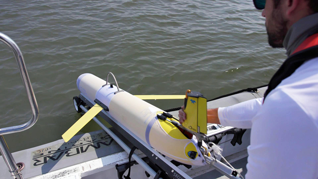
UGA Skidaway Institute research technician Ben Hefner launches a glider into the ocean. Photo courtesy MADLAWMEDIA

Two storms from the 2018 hurricane season provide examples of how quickly storm intensity can change. Hurricane Florence was predicted to be a Category 5 storm, but she weakened significantly before making landfall in North Carolina as a Category 1 storm on September 14. On the other hand, a month later, Hurricane Michael grew from a Category 1 to a Category 5 storm in just two days and hit the Florida panhandle on October 10.

Hurricanes feed off of heat from warm ocean waters like that found in the Caribbean, and in the Gulf Stream and shallow waters off the southeast United States, known as the South Atlantic Bight. This can be a tremendous source of energy for developing storms. Heat is transferred between the ocean and atmosphere at the ocean’s surface, but it is important to understand the amount of subsurface heat as well.

“Places where warm waters near the surface lie over cooler water near bottom, winds and other factors can mix up the water, cooling the surface and limiting the heat available to the atmosphere,” UGA Skidaway Institute researcher Catherine Edwards said. “Satellite data provides a nice picture of where the surface ocean is warm, but the subsurface temperature field remains hidden.”

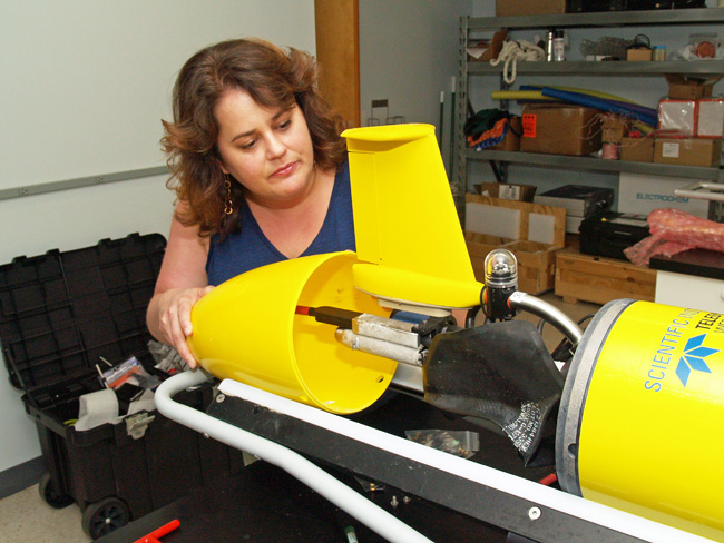
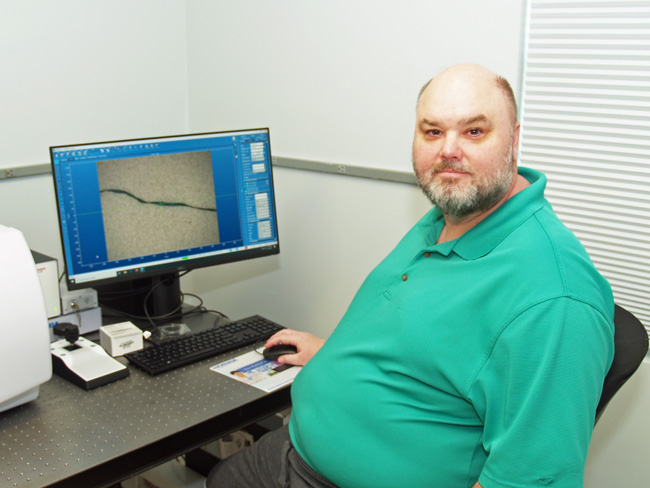
UGA Skidaway Institute researcher Catherine Edwards examines the tail assembly of a glider.

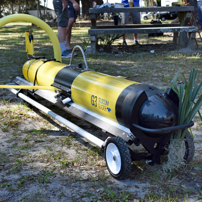
This is where autonomous underwater vehicles, also known as gliders, can collect valuable information. Gliders are torpedo-shaped crafts that can be packed with sensors and sent on underwater missions to collect oceanographic data. The gliders measure temperature and salinity, among other parameters, as they profile up and down in the water. Equipped with satellite phones, the gliders surface periodically to transmit their recorded data during missions that can last from weeks to months.

“This regular communication with the surface allows us to adapt the mission on the fly, and also process and share the data only minutes to hours after it has been measured,” Edwards said. “By using a network of data contributed by glider operators around the world, the U. S. Navy and other ocean modelers can incorporate these data into their predictions, injecting subsurface heat content information into the hurricane models from below.”

The 2018 hurricane season provided Edwards and her colleagues a fortuitous opportunity to demonstrate the value of glider data. Edwards deployed two gliders in advance of Hurricane Florence. One was launched off the North Carolina coast and the other further south, near the South Carolina-Georgia state line. The gliders discovered the models’ ocean temperature forecasts were significantly off target. Edwards points to charts comparing the predictions from ocean models run in the U.S. and Europe with the actual temperatures two days before Florence made landfall.

On the south side of the storm path, the models predicted that the ocean had a warm, slightly fresh layer overtopping cooler, saltier water below, but the glider revealed that the water column was well-mixed and, overall, warmer and fresher than predicted. On the north side of the storm, the models predicted warm, well-mixed water, but the glider detected a sharp temperature change below the surface, with a much cooler layer near-bottom. However, the most surprising part was just how stratified the water was.

“There is almost a 14-degree Celsius (approximately 25 degrees Fahrenheit) error that the glider corrects in the model,” she said. “The model and data agree near-surface, but the models that don’t use the glider data all miss the colder, saltier layer below. The model that incorporated glider data that day is the only one that captures that vertical pattern.”

Not only can gliders provide a unique view of the ocean, they fly on their own, reporting data regularly, before, during and after a hurricane, making them a powerful tool for understanding the effects of storms.

“The glider data is being used in real time,” Edwards said. “These real time observations can improve our hurricane forecasts right now, not just in a paper to be published a year from now.”

Edwards and collaborator Chad Lembke, at the University of South Florida, had a third glider deployed in August before Florence as part of a glider observatory she runs for the Southeast Coastal Ocean Observing Regional Association (SECOORA). While it was recovered about a little over a week before Florence made landfall, the glider helped define the edge of the Gulf Stream, which is an essential ocean feature that is very hard for models to get right.

“So it’s possible that the data from that glider already improved any tropical storm predictions that use ocean models and take that glider data into account, because the Gulf Stream is so important in our region,” Edwards said.

Edwards works with colleagues from other institutions through SECOORA. Together they are making plans for the 2019 hurricane season. Funded by a $220,000 grant from the National Oceanic and Atmospheric Administration, they plan to pre-position a number of gliders in strategic locations to be ready for deployment in advance of incoming storms.

“Gliders are like the weather balloons of the ocean,” Edwards said. “Imagine how powerful a regular network of these kinds of glider observations could be for understanding the ocean and weather, and how they interact.”