Tag Archives: research

UGA Skidaway Institute scientist and grad student attend int’l conference in Vietnam

UGA Skidaway Institute scientist Sara Rivero-Calle and graduate student Mallie Hunt travelled to Quy Nhon, Vietnam, in October to participate in the 25th International Ocean Optics Meeting (https://oceanopticsconference.org). Rivero-Calle focuses much of her work on studying the ocean with satellites.

“It is one of the most specific and relevant meetings for me because it is international,” Rivero-Calle said. “It brought together scientists from all over the world who work on ocean optics and aquatic satellite remote sensing. It also included program managers from NASA and other space agencies, and companies that sell the instruments that I use.”

Mallie Hunt (left) and Sara Rivero-Calle in Vietnam

Rivero-Calle has been attending this semi-annual meeting since she was in graduate school. The meeting was almost a reunion for her with mentors, colleagues and friends she has made in the field, but more important was the trip’s professional purpose.

“It was a big deal for me to attend and let my colleagues know that I have established an ocean optics lab at Skidaway Institute,” she said. “I gave a talk presenting all the projects in my lab, and it was very well received.”

An outdoor poster session at the conference

The conference was not all work and no play. Quy Nhon is a beach town, and both the hotel and conference center were near the ocean.

“The hotel had ocean views, and the conference center was at another location by the beach,” she said. “Lunches were a fully catered Vietnamese splurge of goodness, buffet-style. I ate so many different delicious foods!

“After lunch most of us went swimming in the ocean before the afternoon session. Can’t beat that.”

For Hunt, the trip to the conference was an experience she says she will never forget. “I was able to meet with other researchers in the same field and receive valuable feedback during my poster presentation that will help me in my future work,” she said. “I am so glad I had the opportunity to see a new country and to present the work I have completed over the past year.”

UGA Skidaway Institute scientists receive pre-seed funding

A team led by UGA Skidaway Institute of Oceanography scientist Sara Rivero-Calle has received “pre-seed” funding to develop proposals to use satellite remote sensing tools to study the Earth’s water resources.

In 2020, the UGA Office of Research, in partnership with the Office of the Provost, launched its Teaming for Interdisciplinary Research Pre-Seed Program to encourage UGA faculty to form teams and collaborate around critical areas of research expertise or emerging research topics. The goal is to stimulate the formation of large-scale research teams and position UGA researchers to be more competitive in attracting resources for collaborative research, including internal UGA seed grants and, ultimately, external grant support.

“Water is a key resource on planet Earth,” Rivero-Calle said. “It shapes our food, society, economy, lifestyle, landscape and where we live.

“In fact, 90% of humans live less than 10 kilometers away from a body of water. Therefore, it is imperative to safeguard and understand this precious resource.”

The project, “Satellite Remote Sensing Applications for Global Water Resources,” pulls together expertise from many related research areas, including water quality, sea levels, hurricanes, harmful algal blooms, underground water, freshwater, primary production, sea ice, watersheds, farmlands and coastal hazards.

“The purpose of this group is to bring together an interdisciplinary team of UGA experts in remote sensing technology and water resources to develop proposals targeting these topics,” Rivero-Calle said.

The motivation behind forming the team is the upcoming call for proposals for NASA PACE Satellite Validation Teams. The project is a NASA satellite scheduled for launch in 2024, and PACE stands for Plankton, Aerosol, Cloud, ocean Ecosystem (https://pace.gsfc.nasa.gov/).

NASA is expected to request proposals for validation teams in early 2023. These teams will collect ground-truthing field data that NASA will compare with what the PACE satellite reports. The field data is also important for developing new algorithms (including some to address regional problems, such as South Atlantic Bight) in the future. PACE will provide information on ocean biology, chemistry and water quality, but also about the composition of the atmosphere above it.

“The hyperspectral capabilities of the ocean color sensor have potential to distinguish between groups or even species of plankton,” Rivero-Calle said. “I am very excited about this advanced capability of PACE.”

In addition to Rivero-Calle, the multi-disciplinary team includes Skidaway Institute Director Clark Alexander, a geologist; Skidaway researcher Clifton Buck, a marine chemist; Adam Milewski from the Department of Geology; Bill Miller from the Department of Marine Sciences; Deepak Mishra from the Department of Geography; Lakshmish Ramaswamy from the Department of Computer Science; and Rosanna Rivero from the College of Environment and Design.

That group includes experts in remote sensing, oceanography, big data, machine learning, coastal and inland waters hazards, coastal ecosystems, hydrology, aerosols and computer science.

UGA researchers are well-positioned to work on satellite validation. Rivero-Calle’s lab is currently working on satellite validation of the ocean color SeaHawk CubeSat mission. Skidaway Institute also operates the Research Vessel Savannah, which is equipped with a state-of-the-art optical system that was designed by Rivero-Calle precisely for satellite data validation in a continuous, way whenever the ship is at sea.

The pre-seed funding grant totals $3,750.

Rivero-Calle selected for ocean sensor workshop

University of Georgia Skidaway Institute assistant professor Sara Rivero-Calle was selected to participate in the June 2022 Ocean Observatories Initiative (OOI) Biogeochemical Sensor Data Workshop. Rivero-Calle was one of only a small number of applicants to be selected to participate. Applicants were chosen based on their experience with the various sensor subtypes and their interest in using sensor data from the existing OOI observatories to address novel science questions. The workshop focused on best practices for accessing and using OOI sensor data and brainstorming its scientific applications.

Participants at the end of a three-day Biogeochemical Sensor Workshop held at Woods Hole Oceanographic Institution June 17-19, 2022. Rivero-Calle is front and center in black top and light blue jeans. Photo: Mai Maheigan ©WHOI.

Rivero-Calle was recently awarded a National Science Foundation Ocean Instrumentation grant to install a suite of optical biogeochemical sensors on the Reseach Vessel Savannah. The project is called BiOMe (Biogeochemical Optical Measurements).

“This is a great opportunity,” Rivero-Calle said. “I enjoyed learning from my colleagues and developing ideas for collaborations using our new sensors on the R/V Savannah.”

The workshop was held at Woods Hole Oceanographic Institution.

UGA Skidaway Institute grad student receives advanced training on the French Rivera

By MD Masud-Ul-Alam
Light, physics, sensors, satellites, and the ocean! All these are essential components of the International Ocean-Colour Coordinating Group Summer Lecture Series on Ocean Optics. I am a doctoral student at Sara Rivero-Calle’s Bio-Optics and Satellite Oceanography Lab and was one of the 24 selected participants from 19 countries. This was a training program that provided knowledge on advanced topics on marine optics and remote sensing. It was held at the Laboratoire d’Océanographie de Villefranche, which is part of the Institut de la Mer, de Villefranche at Villefranche-sur-Mer from July 18-19.

The course consisted of practical and laboratory sessions, and theory lectures. The lab work included hands-on training on how to collect the highest quality in situ data and how to calibrate different optical sensors (in situ and satellite). The theoretical lectures covered the optical properties of light, interactions with marine particles, inherent optical properties, apparent optical properties and more.

In addition, the intensive lab sessions incorporated trainings on different software and optical instrumentation, such as AC-S and HydroLight, different models for atmospheric corrections and working on a group project using Sentinel-2, and Sentinel-3 datasets.

Overall, this summer course gave me and my fellow students the opportunity to meet experts across the globe and develop networks for future collaborative research work.

Port Lympia in nearby Nice.

I am so glad I was able to participate in this course. This was such a great opportunity to meet the ocean-optics experts across the globe and make new friends to work with. Beside the course, I enjoyed the beauty of Villefranche-sur-Mer and Nice!

Scientists and students participate in Hawaii research cruise

After two years of delay due to the COVID-19 pandemic, University of Georgia Skidaway Institute scientists participated in the first cruise of their four-year project to study how dust in the atmosphere is deposited in the ocean and how that affects chemical and biological processes there. The team of Daniel Ohnemus and Chris Marsay, along with graduate students Charlotte “Charlie” Kollman and Mariah Ricci, joined the University of Hawaii Research Vessel Kilo Moana on a cruise out of Oahu. They collected samples at the Hawaii Ocean Time-Series Station Aloha – a six-mile wide section of ocean approximately 122 miles from Oahu – where oceanographers from around the world study ocean conditions over long time spans. The cruise was the first of six planned during the four-year project.

Research Vessel Kilo Moana

Ohnemus is one of two chief scientists on the project along with fellow UGA Skidaway Institute researcher Clifton Buck, who did not join this cruise. He called the cruise a success.

“Everything we put in the ocean, we got back, and that’s a good thing in oceanography,” he said. “And also, most importantly, it all worked.”

The overall goal of the project is to look at the rate at which dust is deposited into the ocean and what happens to it once it is in the water column. The chemistry of the ocean can be changed by the introduction and removal of elements, including trace elements which are present in low concentrations. In some cases, these elements are known to be vital to biological processes and ocean food webs.
After waiting for two years for the pandemic to ease, the science team still had additional waiting once they arrived in Hawaii. They were required to quarantine in a hotel for six days before being allowed to board the ship.

“We flew in about a week before we were expected on the ship. We got tested multiple times,” Ohnemus said. “We tested at the airport. We got a PCR test mid-quarantine. And we were tested again before boarding the ship.

“We knew we definitely did not have COVID.”

Mariah Ricci, Charlie Kollman and Dan Ohnemus prepare to deploy an instrument package.

“The hardest part is that we were out there for five days and four nights, and all of our research and sampling took place in the last eight hours of the cruise,” Ohnemus said.

For the students Charlie Kollman and Mariah Ricci the cruise was a new experience. It was Ricci’s first research cruise ever. Ironically, she and Ohnemus both took their first cruise on the RV Kilo Moana, only their cruises were 15 years apart.

Dan Ohnemus and Charlie Kollman deploy a package of sensors.

For Kollman, the best part of the cruise was participating in all the work necessary to conduct the science activity from the planning process all the way through to the end and then seeing the fruits of her labor.

“It was a great experience,” she said. “It is really rewarding to see all the different things we had to do like all the mechanical work.

“I think people often think of science as being constantly high value or in the lab doing really complicated stuff, but a lot of times it’s running to Home Depot four times because you don’t have the correct pipe fitting.”

Ohnemus sings the praises of his collaborators at the University of Hawaii. “They are excellent. It was great to be able sail with them after all this time,” he said. “We first wrote the proposal in 2018, and to actually get to sail together four years later was very rewarding and time well spent.”

Hurricane glider completes marathon mission

By Nadine Slimak and Michael Sullivan

When the Slocum glider known as NG645 was deployed about 80 miles south of New Orleans on Oct. 10, 2021, it became one of the most closely watched ocean-observing instruments in the Gulf of Mexico. That’s because it was a small robot with a big mission – to investigate features of the Loop Current and Loop Current Eddies in the Gulf as part of the Hurricane Glider Project – then navigate on a mission never attempted by an unmanned glider before.

“Our goal with this project was to deploy a glider in the Gulf of Mexico and then navigate it through the spatially variable currents of the Loop Current and into the Gulf Stream all the way around the bend of Florida up to the coast of South Carolina,” said UGA Skidaway Institute of Oceanography researcher Catherine Edwards, one of the glider team leaders and who was responsible for the glider once it rounded the tip of Florida.

The glider path is shown in red from the Gulf of Mexico to the Atlantic Ocean off the coast of South Carolina.

The trip was a test to see whether the glider could successfully navigate around Florida and up the East Coast while gaining information about multiple marine systems – all during a single mission. With no propeller or motor, it would have to do so using minimal battery power and only buoyancy to travel.

Slocum gliders, also known as autonomous underwater vehicles (AUVs), are torpedo-shaped underwater robots about six feet long and eight inches in diameter that carry instrument packages to gather data on water temperature, salinity, dissolved oxygen and other ocean parameters, depending on ocean-observation needs. The gliders use buoyancy to move throughout the water column in a vertical yo-yo pattern, taking in water to move down through the water column and expelling water to return to the surface. The wings on the glider then give it lift that allows it to move forward. When the glider surfaces, it sends data to a satellite, which beams it back to scientists in the lab. Back in the laboratory, glider pilots can update and adjust glider trajectories to ensure they remain on course, or even change their paths.

NG645’s initial mission was to gather information on the Loop Current and Loop Current Eddies, major oceanographic features in the Gulf of Mexico.

“The Loop Current is sort of an arm of the western boundary current that eventually becomes the Gulf Stream,” Edwards said. “That’s one of the major features that this project seeks to capture. Just like we’re monitoring the edge of the Gulf Stream with our gliders, these are areas where the models need the most improvement, and where our observations can have the greatest impact.”

The glider is recovered off the coast of South Carolina.

The glider was a part of the Hurricane Glider Project, a series of gliders monitoring the ocean in the Gulf, Caribbean Sea and Atlantic that are programmed to collect information on ocean parameters from areas where tropical storms and hurricanes typically form or strengthen. Gliders gather temperature and salinity readings from throughout the water column, not just at the surface, and send it back to the National Oceanic and Atmospheric Administration in near-real time to improve the accuracy of upper ocean models used to create hurricane intensity forecasts. This was the first-time glider operators attempted such an ambitious mission.

“There were so many firsts during this mission,” said Kerri Whilden, a researcher from Texas A&M University, who led the collaboration in the Gulf before handing it off to Edwards as it rounded Key West and navigated up the East Coast. “It would be the first time we started piloting a glider in the Gulf and then sent it through the Gulf Stream around the tip of Florida, then on to South Carolina. It involved coordinating a lot of different organizations to deploy the glider, to pilot it and then to retrieve it at the end of its mission. It was a big team collaboration for sure.”

In addition to UGA Skidaway Institute and Texas A&M, other partners in the project included the Naval Oceanographic Office, the U.S. Integrated Ocean Observing System, the Gulf of Mexico Coastal Ocean Observing System, the Southeast Coastal Ocean Observing Regional Association, the Underwater Glider User Group, the University of Southern Mississippi, NOAA’s Atlantic Oceanographic and Meteorological Laboratory and the Woods Hole Oceanographic Institute.

Planning is under way for a repeat mission in 2022.

Paper by UGA Skidaway Institute scientist featured in prominent journal

A research paper by University of Georgia Skidaway Institute of Oceanography scientist Natalie Cohen was selected as the cover article in the February issue of the journal Nature Microbiology.

The paper, “Dinoflagellates alter their carbon and nutrient metabolic strategies across environmental gradients in the central Pacific Ocean,” was based on data a team of fellow researchers collected on a 2011 cruise in the equatorial Pacific Ocean. Dinoflagellates are tiny plankton, many of which are capable of using photosynthesis in addition to eating small prey.

They play a fundamental role in the biogeochemical cycles in the ocean by transferring energy from lower to higher life forms and also transporting carbon vertically in the water column.

“Some dinoflagellates can travel vertically in the water column using their flagella,” said Cohen, the lead author of the paper. “Some are also capable of bioluminescence which can light up the sea surface at night.

“They are found throughout the world’s oceans and an important component of the ocean carbon cycle.”

When the scientists analyzed the data from the cruise, they discovered a greater abundance of dinoflagellates than they expected. Researchers found the dinoflagellates were abundant both in the sunlit surface ocean and also in deeper, darker waters. This relative abundance in two drastically different environments lead the researchers to conclude the dinoflagellates must change how they function as they move from one depth zone to the other.

Cohen conducted the research while she was a postdoctoral fellow at Woods Hole Oceanographic Institution.

Along with Cohen, the other members of the research team include Matthew McIlvin, Dawn Moran, Noelle Held, Jaclyn Saunders, Mak Saito and Michael Brosnahan, all from Woods Hole; Nicholas Hawco from the University of Southern California; Giacomo R. DiTullio from the College of Charleston; Carl Lamborg from the University of California, Santa Cruz; and John McCrow, Chris Dupont, Andrew Allen, all from the J. Craig Venter Institute.

The entire paper can be viewed at the journal website.

Scientific serendipity: Researchers make surprising finding on ocean’s ‘thin layers’

Sometimes scientists start out researching one subject, but along the way, they come across something else even more interesting. This is what happened to University of Georgia Skidaway Institute of Oceanography researcher Adam Greer in the summer of 2016 when Greer was a post-doctoral associate at the University of Southern Mississippi. That fortuitous event resulted in a paper recently published in the journal Limnology and Oceanography with Greer as the lead author.

Adam Greer 1 650pGreer and his fellow researchers were on a cruise in the northern Gulf of Mexico to study the effects of river input on biological processes. They came across a natural phenomenon called a thin layer. These are oceanographic features found all over the world where biomass collects into a narrow portion of the water column–less than five meters thick vertically–and can extend for several kilometers horizontally. They tend to occur in stratified shelf systems.

“Surprisingly, there are few published studies on thin layers in the northern Gulf of Mexico, which is heavily influenced by rivers and highly stratified during the summer,” Greer said. “Thin layers are important because they are trophic hot spots, where life tends to congregate, and predators and prey interact.”

However, Greer said, thin layers are very difficult to analyze because they occur within a restricted portion of the water column, and most conventional ocean sampling equipment will not detect their influence on different organisms.

Greer and his colleagues were better equipped than most to study the thin layer. Rather than laying out a grid and taking a series of water samples, they were equipped with an In Situ Ichthyoplankton Imaging System (ISIIS). This imaging system was towed behind their research vessel and undulated through the water column, producing a live feed of plankton images and oceanographic data. By studying the video, they were able to map the distributions of many different types of organisms in great detail. The thin layer was composed of large chains of phytoplankton called diatoms and gelatinous zooplankton called doliolids.

Thin Layer 2

A crewman launches the ISIIS.

“Although we expected many different organisms to aggregate within the layer, this was not the case,” Greer said. “The only organisms that were concentrated within the layer were gelatinous organisms called doliolids. Other organisms that we expected to see, such as copepods, chaetognaths and shrimp, tended to congregate near the surface just south of the thin layer.”

The researchers determined that the area south of the thin layer was influenced by a surface convergence – two water masses colliding and pushing water downward at a slow rate. They believe that many organisms with active swimming ability, such as shrimps and copepods, could stay within the surface convergence, while more passive swimmers, such as doliolids would follow the trajectory of the thin layer and diatoms.

Thin Layer 1

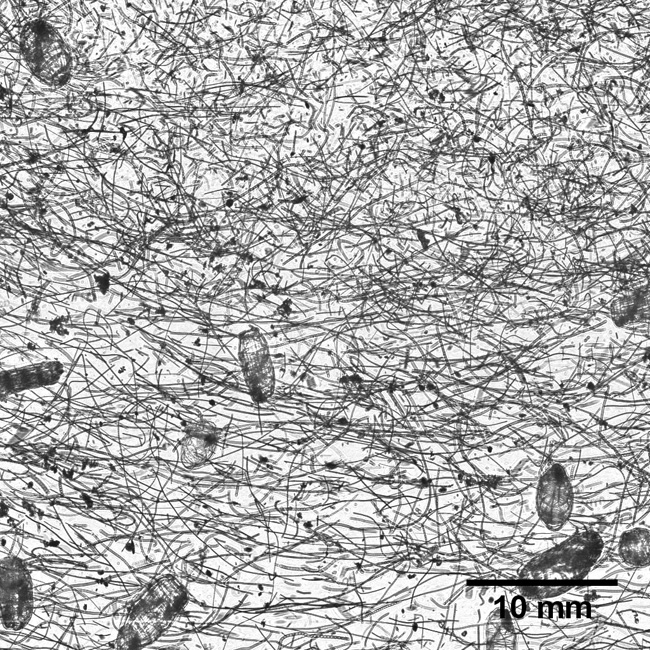
An image from the In Situ Ichthyoplankton Imaging System passing through the thin layer. The long, slender filaments are chains of diatoms. The larger, oval plankton are doliolids

Greer and his colleagues discovered several other characteristics of the thin layer they had not anticipated. There was a higher concentration of live phytoplankton than expected. As a result, the thin layer also had a high concentration of dissolved oxygen due to the photosynthetic activity. The zooplankton were also aggregated into distinct microhabitats with different oceanographic properties — such as temperature, salinity and light. The microhabitats also contained different types and abundances of food.

“For a lot of these organisms, if you took the average abundance of food it wouldn’t be enough to survive,” Greer said. “So whatever mechanisms there are to create higher abundances of food, they are potentially really important for a number of different organisms.”

The other members of the research team were Adam Boyette, Valerie Cruz, Kemal Cambazoglu, Luciano Chiaverano and Jerry Wiggert, all from the University of Southern Mississippi; Brian Dzwonkowski and Steven Dykstra, from the University of South Alabama; and Christian Briseño‐Avena and Bob Cowen, from Oregon State University.
The paper can be viewed HERE.

Marine scientists map fish habitats

by Alan Flurry

Beyond the barrier islands of coastal Georgia, the continental shelf extends gradually eastward for almost 80 miles to the Gulf Stream. This broad, sandy shelf largely does not provide the firm foundation needed for the development of reef communities to support recreational and commercial fish species including grouper, snapper, black sea bass and amberjack.

“Natural and artificial reef habitats are important to Georgia fisheries because they provide hard, permanent structure on the Georgia shelf, which is dominantly a vast underwater desert of shifting sands,” said Clark Alexander, professor and director of the University of Georgia Skidaway Institute of Oceanography. “The Georgia Department of Natural Resources has invested significantly over the past several years in developing the capacity to map these areas to enhance the management of these reef communities.“

To increase the availability of high-quality hard bottom areas off Georgia, the DNR began an artificial reef-building program in 1971 to deploy materials at various locations across the continental shelf, from 2 to 30 miles offshore. Reef materials include concrete slabs and culverts from road, bridge and building demolition, subway cars, ships, barges, and U.S. Army tanks. Because some of these reefs are far offshore and DNR resources are limited, the status of some of that material has not been examined for decades.

Ossabaw sound 650p sq

A bathymetric survey of Ossabaw Sound.

For the past five years, Alexander has been leading an effort to improve understanding of marine, coastal and estuarine habitats and functions using high-resolution sonar to map state water bottoms, with funding from the DNR Coastal Incentive Grant program. Alexander’s team has amassed critical depth and habitat information for five of Georgia’s sounds (Wassaw, Ossabaw, St. Catherine’s, Doboy and Sapelo), revealing deeply scoured areas where underwater cliffs have formed to create hard substrate where complex ecosystems and biological communities have developed.

“These inshore, hardbottom habitats should enhance biodiversity in the areas near these structures and enhance ecosystems supporting both commercial and recreational species across the continental shelf,” Alexander said.

Alexander is currently leading a new, three-year project mapping important fish habitats in state waters — the newly discovered estuarine habitats, and artificial reef structures within 10 nautical miles of shore – those areas most accessible to recreational anglers, boaters and divers. In addition, his research group is mapping previously unmapped portions of the sounds and tidal rivers deeper than 15 meters to discover the extent of these newly identified estuarine hardbottom habitats.

Skidaway Institute researchers will work with DNR to update the online “Boater’s Guide to Artificial Reefs” with accurate locations and imagery of deployed materials for these reefs. These new, more accurate artificial reef surveys will also document recent changes in the locations and integrity of placed materials and verify the low-tide water depths over all features in the artificial reefs to enhance navigational safety.

New high-tech microscope to bolster UGA Skidaway Institute’s microplastics research

A new, high-tech microscope is giving scientists at the University of Georgia Skidaway Institute of Oceanography a tool to study the tiniest particles and organisms in our environment in a whole new light. The Horiba Jobin Yvon XplorRA Plus Confocal Raman microscope uses lasers, rather than conventional light or a stream of electrons, to examine objects measuring smaller than a millionth of a meter or .04 thousandths of an inch.

“The way a Raman microscope works is fundamentally different from how conventional microscopes, such as those found in the classroom, operate,” UGA Skidaway Institute scientist Jay Brandes said. “With this instrument, a high energy laser beam is directed at the sample, and the instrument measures the light scattered back from it.”
OLYMPUS DIGITAL CAMERA

UGA Skidaway Institute researcher Jay Brandes with the Raman microscope.

What distinguishes it even more from traditional microscopes is a phenomenon called the Raman effect. This was discovered in the 1930s by Indian physicist Chandrasekhara Venkata Raman. With the Raman microscope, some of the scattered light comes from interactions with the molecules in the sample, and these interactions leave a spectral “fingerprint” that can be isolated from the laser light and measured. Those “fingerprints” can tell scientists what the material is made of, whether it is natural organics like bacteria or detritus, inorganic minerals or plastics.

“Because it uses a high tech, automated microscope to perform these measurements, maps of sample composition and even three-dimensional maps are possible,” Brandes said.

OLYMPUS DIGITAL CAMERA

The Raman microscope uses a laser to illuminate and analyze an object.

One immediate use for this instrument will be to study microplastic pollution in Georgia’s coastal environment. Brandes and a group of educators, students and volunteers, have been researching the microplastic pollution issue in coastal Georgia for several years. He says that locating and identifying microplastics in the environment or in an organism is difficult because of their tiny size.

“It’s not like it is a water bottle where you can look it and say ‘That’s plastic,’” Brandes said. “We see all kinds of microscopic particles, and, because they are so small and not always distinctively colored or shaped, it is difficult to distinguish microplastics from other substances.

“With this microscope, we will be able to look at a fiber and tell whether it is made of polyester, nylon, kevlar or whatever.”

Laser Microscope 3

A microfiber as seen by the Raman microscope.

Brandes and his team have been looking at the microplastics problem from several angles. They have taken hundreds of water samples along the Georgia coast, filtered the samples and analyzed the captured particles and fibers. The researchers also examine marine organisms, like fish and oysters, to see what organisms are consuming the microplastics and to what extent.

The instrument will allow sub-micron analysis of complex samples from a wide variety of other projects. It will be available to UGA Skidaway Institute scientists as well as other scientists from throughout the Southeast. In addition to benefitting researchers, the Raman microscope will enhance educational programs conducted at Skidaway Institute and the through the UGA Department of Marine Sciences. Once a set of standard methods and protocols have been established, it will also be available to support scientific research from institutions and organizations from around the Southeast.

The instrument was purchased with a $207,000 grant from the National Science Foundation.