UGA Skidaway Institute graduate student Kun Ma was awarded her doctoral degree in marine sciences at UGA’s December Commencement ceremony. UGA Skidaway Institute Professor Jay Brandes was Ma’s advisor.
Kun Ma
Ma joined Brandes’ lab in 2017 and focused her research on the photochemical degradation of carbon in the surface ocean.
Two UGA Skidaway Institute-based graduate students were awarded prizes by the Department of Marine Sciences. Doctoral student Ben Lowin from Assistant Professor Sara Rivero-Calle’s lab received the Graduate Student Service and Outreach Award.
Kyle Aaron received the Graduate Student Teaching Award for his work as a teaching assistant in the Semester@Skidaway program. Both awards included a $250 prize. Aaron also graduated with his master’s degree in December.
UGA Skidaway Institute scientist Sara Rivero-Calle and graduate student Mallie Hunt travelled to Quy Nhon, Vietnam, in October to participate in the 25th International Ocean Optics Meeting (https://oceanopticsconference.org). Rivero-Calle focuses much of her work on studying the ocean with satellites.
“It is one of the most specific and relevant meetings for me because it is international,” Rivero-Calle said. “It brought together scientists from all over the world who work on ocean optics and aquatic satellite remote sensing. It also included program managers from NASA and other space agencies, and companies that sell the instruments that I use.”
Mallie Hunt (left) and Sara Rivero-Calle in Vietnam
Rivero-Calle has been attending this semi-annual meeting since she was in graduate school. The meeting was almost a reunion for her with mentors, colleagues and friends she has made in the field, but more important was the trip’s professional purpose.
“It was a big deal for me to attend and let my colleagues know that I have established an ocean optics lab at Skidaway Institute,” she said. “I gave a talk presenting all the projects in my lab, and it was very well received.”
An outdoor poster session at the conference
The conference was not all work and no play. Quy Nhon is a beach town, and both the hotel and conference center were near the ocean.
“The hotel had ocean views, and the conference center was at another location by the beach,” she said. “Lunches were a fully catered Vietnamese splurge of goodness, buffet-style. I ate so many different delicious foods!
“After lunch most of us went swimming in the ocean before the afternoon session. Can’t beat that.”
For Hunt, the trip to the conference was an experience she says she will never forget. “I was able to meet with other researchers in the same field and receive valuable feedback during my poster presentation that will help me in my future work,” she said. “I am so glad I had the opportunity to see a new country and to present the work I have completed over the past year.”
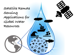
A team led by UGA Skidaway Institute of Oceanography scientist Sara Rivero-Calle has received “pre-seed” funding to develop proposals to use satellite remote sensing tools to study the Earth’s water resources.
In 2020, the UGA Office of Research, in partnership with the Office of the Provost, launched its Teaming for Interdisciplinary Research Pre-Seed Program to encourage UGA faculty to form teams and collaborate around critical areas of research expertise or emerging research topics. The goal is to stimulate the formation of large-scale research teams and position UGA researchers to be more competitive in attracting resources for collaborative research, including internal UGA seed grants and, ultimately, external grant support.
“Water is a key resource on planet Earth,” Rivero-Calle said. “It shapes our food, society, economy, lifestyle, landscape and where we live.
“In fact, 90% of humans live less than 10 kilometers away from a body of water. Therefore, it is imperative to safeguard and understand this precious resource.”
The project, “Satellite Remote Sensing Applications for Global Water Resources,” pulls together expertise from many related research areas, including water quality, sea levels, hurricanes, harmful algal blooms, underground water, freshwater, primary production, sea ice, watersheds, farmlands and coastal hazards.
“The purpose of this group is to bring together an interdisciplinary team of UGA experts in remote sensing technology and water resources to develop proposals targeting these topics,” Rivero-Calle said.
The motivation behind forming the team is the upcoming call for proposals for NASA PACE Satellite Validation Teams. The project is a NASA satellite scheduled for launch in 2024, and PACE stands for Plankton, Aerosol, Cloud, ocean Ecosystem (https://pace.gsfc.nasa.gov/).
NASA is expected to request proposals for validation teams in early 2023. These teams will collect ground-truthing field data that NASA will compare with what the PACE satellite reports. The field data is also important for developing new algorithms (including some to address regional problems, such as South Atlantic Bight) in the future. PACE will provide information on ocean biology, chemistry and water quality, but also about the composition of the atmosphere above it.
“The hyperspectral capabilities of the ocean color sensor have potential to distinguish between groups or even species of plankton,” Rivero-Calle said. “I am very excited about this advanced capability of PACE.”
In addition to Rivero-Calle, the multi-disciplinary team includes Skidaway Institute Director Clark Alexander, a geologist; Skidaway researcher Clifton Buck, a marine chemist; Adam Milewski from the Department of Geology; Bill Miller from the Department of Marine Sciences; Deepak Mishra from the Department of Geography; Lakshmish Ramaswamy from the Department of Computer Science; and Rosanna Rivero from the College of Environment and Design.
That group includes experts in remote sensing, oceanography, big data, machine learning, coastal and inland waters hazards, coastal ecosystems, hydrology, aerosols and computer science.
UGA researchers are well-positioned to work on satellite validation. Rivero-Calle’s lab is currently working on satellite validation of the ocean color SeaHawk CubeSat mission. Skidaway Institute also operates the Research Vessel Savannah, which is equipped with a state-of-the-art optical system that was designed by Rivero-Calle precisely for satellite data validation in a continuous, way whenever the ship is at sea.
University of Georgia Skidaway Institute assistant professor Sara Rivero-Calle was selected to participate in the June 2022 Ocean Observatories Initiative (OOI) Biogeochemical Sensor Data Workshop. Rivero-Calle was one of only a small number of applicants to be selected to participate. Applicants were chosen based on their experience with the various sensor subtypes and their interest in using sensor data from the existing OOI observatories to address novel science questions. The workshop focused on best practices for accessing and using OOI sensor data and brainstorming its scientific applications.
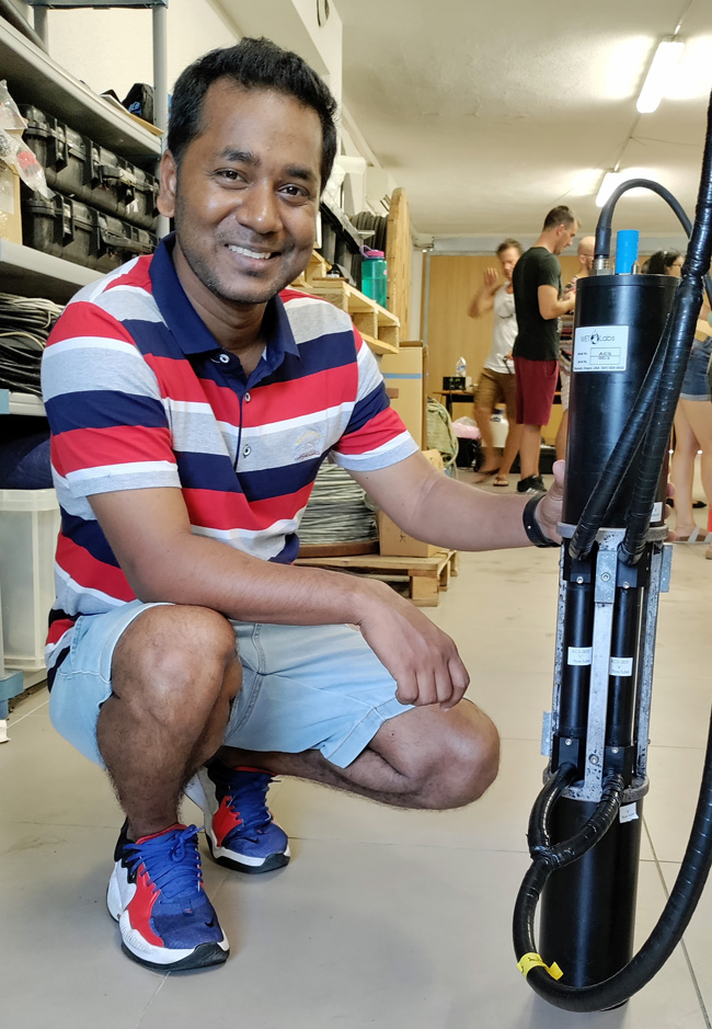
Rivero-Calle was recently awarded a National Science Foundation Ocean Instrumentation grant to install a suite of optical biogeochemical sensors on the Reseach Vessel Savannah. The project is called BiOMe (Biogeochemical Optical Measurements).
“This is a great opportunity,” Rivero-Calle said. “I enjoyed learning from my colleagues and developing ideas for collaborations using our new sensors on the R/V Savannah.”
The workshop was held at Woods Hole Oceanographic Institution.
By MD Masud-Ul-Alam Light, physics, sensors, satellites, and the ocean! All these are essential components of the International Ocean-Colour Coordinating Group Summer Lecture Series on Ocean Optics. I am a doctoral student at Sara Rivero-Calle’s Bio-Optics and Satellite Oceanography Lab and was one of the 24 selected participants from 19 countries. This was a training program that provided knowledge on advanced topics on marine optics and remote sensing. It was held at the Laboratoire d’Océanographie de Villefranche, which is part of the Institut de la Mer, de Villefranche at Villefranche-sur-Mer from July 18-19.
The course consisted of practical and laboratory sessions, and theory lectures. The lab work included hands-on training on how to collect the highest quality in situ data and how to calibrate different optical sensors (in situ and satellite). The theoretical lectures covered the optical properties of light, interactions with marine particles, inherent optical properties, apparent optical properties and more.
In addition, the intensive lab sessions incorporated trainings on different software and optical instrumentation, such as AC-S and HydroLight, different models for atmospheric corrections and working on a group project using Sentinel-2, and Sentinel-3 datasets.
Overall, this summer course gave me and my fellow students the opportunity to meet experts across the globe and develop networks for future collaborative research work.
Port Lympia in nearby Nice.
I am so glad I was able to participate in this course. This was such a great opportunity to meet the ocean-optics experts across the globe and make new friends to work with. Beside the course, I enjoyed the beauty of Villefranche-sur-Mer and Nice!
University of Georgia Skidaway Institute of Oceanography director Clark Alexander was voted the 2022-23 president-elect of the Southern Association of Marine Laboratories (SAML) and will serve as president for 2023-2024.
SAML is a regional organization within the National Association of Marine Laboratories. It is comprised of 48 marine laboratories and governmental agencies stretching from Virginia to Texas and including Bermuda. Its purpose is to promote cooperation and effectiveness of member institutions in their work on marine and coastal resources, as well as share solutions to issues facing coastal field installations.
Alexander is a coastal and marine geologist who joined the Skidaway Institute as a post-doctoral scientist in 1989, achieved the rank of full professor in 2003 and was appointed director in 2016. He earned bachelor’s degrees in oceanography and geology from Humboldt State University in California. He went on to earn his master’s and doctoral degrees in marine geology from North Carolina State University.
As a researcher, Alexander has participated in 64 field programs from New Zealand to Siberia and has been the chief scientist on 29 oceanographic cruises with a total of more than two years at sea. He has published 92 papers in scientific journals, and, in the past decade, has received more than $4 million in direct research funding. From 2003-2017, he also served as the director of the Georgia Southern University Applied Coastal Research Laboratory on Skidaway Island.
Alexander has been very active on federal, state and regional advisory boards and has worked closely with the US Army Corps of Engineers, South Atlantic Fisheries Management Council, Governors’ South Atlantic Alliance, and the Georgia Department of Natural Resources to identify and address pressing coastal management needs. He served on the Georgia Coastal Marshlands Protection Committee and the Georgia Shore Protection Committee, which permit all major activities within the state’s marshes and beaches, from 1998 to 2006.
Graduate students from the University of Georgia’s Department of Marine Science gathered at UGA Skidaway Institute of Oceanography on the weekend of May 27 for a program aimed at improving graduate student retention, inclusion, well-being and a sense of belonging.
The marine science graduate students are split between the UGA Skidaway Institute and the main campus in Athens. Given the 250-mile distance between Athens and the Georgia coast, these two groups of students typically only interact during online instruction, webinars, meetings or on an occasional research cruise. They rarely gather in-person in a casual setting.
“It was a really great experience,” said UGA Skidaway Institute assistant professor Sara Rivero-Calle. “Because they are split between the two campuses, many of these students had never met in person. They had worked together remotely on assignments and seen each other through the computer screen, but this was the first time they could relax and enjoy each other’s company in real life.”
A group of students enjoying an evening out.
The event included a guest speaker, Virginia Schutte, who led a workshop on science communication and the best ways for students to market themselves. The students also organized a clean-up of some of the trails on Skidaway Island, utilizing bags from UGA Marine Extension’s trawl-to-trash program.
“The UGA marine science students had a wonderful event supported by the UGA Marine Science Department and the Skidaway Institute of Oceanography,” said Frank Mcquarrie, president of the marine sciences graduate student association. “Meeting in person was invaluable, and it reminded us that we are stronger together.”
The program was funded by a $5,000 grant from the UGA Graduate School.
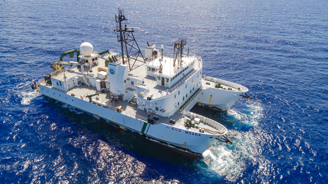
After two years of delay due to the COVID-19 pandemic, University of Georgia Skidaway Institute scientists participated in the first cruise of their four-year project to study how dust in the atmosphere is deposited in the ocean and how that affects chemical and biological processes there. The team of Daniel Ohnemus and Chris Marsay, along with graduate students Charlotte “Charlie” Kollman and Mariah Ricci, joined the University of Hawaii Research Vessel Kilo Moana on a cruise out of Oahu. They collected samples at the Hawaii Ocean Time-Series Station Aloha – a six-mile wide section of ocean approximately 122 miles from Oahu – where oceanographers from around the world study ocean conditions over long time spans. The cruise was the first of six planned during the four-year project.
Research Vessel Kilo Moana
Ohnemus is one of two chief scientists on the project along with fellow UGA Skidaway Institute researcher Clifton Buck, who did not join this cruise. He called the cruise a success.
“Everything we put in the ocean, we got back, and that’s a good thing in oceanography,” he said. “And also, most importantly, it all worked.”
The overall goal of the project is to look at the rate at which dust is deposited into the ocean and what happens to it once it is in the water column. The chemistry of the ocean can be changed by the introduction and removal of elements, including trace elements which are present in low concentrations. In some cases, these elements are known to be vital to biological processes and ocean food webs. After waiting for two years for the pandemic to ease, the science team still had additional waiting once they arrived in Hawaii. They were required to quarantine in a hotel for six days before being allowed to board the ship.
“We flew in about a week before we were expected on the ship. We got tested multiple times,” Ohnemus said. “We tested at the airport. We got a PCR test mid-quarantine. And we were tested again before boarding the ship.
“We knew we definitely did not have COVID.”
Mariah Ricci, Charlie Kollman and Dan Ohnemus prepare to deploy an instrument package.
“The hardest part is that we were out there for five days and four nights, and all of our research and sampling took place in the last eight hours of the cruise,” Ohnemus said.
For the students Charlie Kollman and Mariah Ricci the cruise was a new experience. It was Ricci’s first research cruise ever. Ironically, she and Ohnemus both took their first cruise on the RV Kilo Moana, only their cruises were 15 years apart.
Dan Ohnemus and Charlie Kollman deploy a package of sensors.
For Kollman, the best part of the cruise was participating in all the work necessary to conduct the science activity from the planning process all the way through to the end and then seeing the fruits of her labor.
“It was a great experience,” she said. “It is really rewarding to see all the different things we had to do like all the mechanical work.
“I think people often think of science as being constantly high value or in the lab doing really complicated stuff, but a lot of times it’s running to Home Depot four times because you don’t have the correct pipe fitting.”
Ohnemus sings the praises of his collaborators at the University of Hawaii. “They are excellent. It was great to be able sail with them after all this time,” he said. “We first wrote the proposal in 2018, and to actually get to sail together four years later was very rewarding and time well spent.”
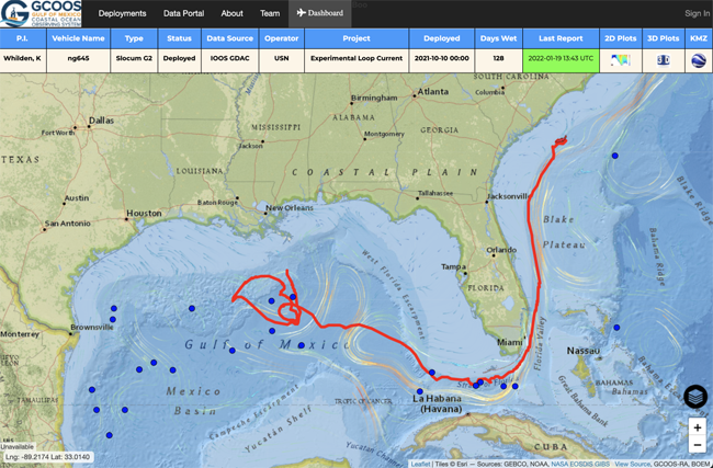
When the Slocum glider known as NG645 was deployed about 80 miles south of New Orleans on Oct. 10, 2021, it became one of the most closely watched ocean-observing instruments in the Gulf of Mexico. That’s because it was a small robot with a big mission – to investigate features of the Loop Current and Loop Current Eddies in the Gulf as part of the Hurricane Glider Project – then navigate on a mission never attempted by an unmanned glider before.
“Our goal with this project was to deploy a glider in the Gulf of Mexico and then navigate it through the spatially variable currents of the Loop Current and into the Gulf Stream all the way around the bend of Florida up to the coast of South Carolina,” said UGA Skidaway Institute of Oceanography researcher Catherine Edwards, one of the glider team leaders and who was responsible for the glider once it rounded the tip of Florida.
The glider path is shown in red from the Gulf of Mexico to the Atlantic Ocean off the coast of South Carolina.
The trip was a test to see whether the glider could successfully navigate around Florida and up the East Coast while gaining information about multiple marine systems – all during a single mission. With no propeller or motor, it would have to do so using minimal battery power and only buoyancy to travel.
Slocum gliders, also known as autonomous underwater vehicles (AUVs), are torpedo-shaped underwater robots about six feet long and eight inches in diameter that carry instrument packages to gather data on water temperature, salinity, dissolved oxygen and other ocean parameters, depending on ocean-observation needs. The gliders use buoyancy to move throughout the water column in a vertical yo-yo pattern, taking in water to move down through the water column and expelling water to return to the surface. The wings on the glider then give it lift that allows it to move forward. When the glider surfaces, it sends data to a satellite, which beams it back to scientists in the lab. Back in the laboratory, glider pilots can update and adjust glider trajectories to ensure they remain on course, or even change their paths.
NG645’s initial mission was to gather information on the Loop Current and Loop Current Eddies, major oceanographic features in the Gulf of Mexico.
“The Loop Current is sort of an arm of the western boundary current that eventually becomes the Gulf Stream,” Edwards said. “That’s one of the major features that this project seeks to capture. Just like we’re monitoring the edge of the Gulf Stream with our gliders, these are areas where the models need the most improvement, and where our observations can have the greatest impact.”
The glider is recovered off the coast of South Carolina.
The glider was a part of the Hurricane Glider Project, a series of gliders monitoring the ocean in the Gulf, Caribbean Sea and Atlantic that are programmed to collect information on ocean parameters from areas where tropical storms and hurricanes typically form or strengthen. Gliders gather temperature and salinity readings from throughout the water column, not just at the surface, and send it back to the National Oceanic and Atmospheric Administration in near-real time to improve the accuracy of upper ocean models used to create hurricane intensity forecasts. This was the first-time glider operators attempted such an ambitious mission.
“There were so many firsts during this mission,” said Kerri Whilden, a researcher from Texas A&M University, who led the collaboration in the Gulf before handing it off to Edwards as it rounded Key West and navigated up the East Coast. “It would be the first time we started piloting a glider in the Gulf and then sent it through the Gulf Stream around the tip of Florida, then on to South Carolina. It involved coordinating a lot of different organizations to deploy the glider, to pilot it and then to retrieve it at the end of its mission. It was a big team collaboration for sure.”
In addition to UGA Skidaway Institute and Texas A&M, other partners in the project included the Naval Oceanographic Office, the U.S. Integrated Ocean Observing System, the Gulf of Mexico Coastal Ocean Observing System, the Southeast Coastal Ocean Observing Regional Association, the Underwater Glider User Group, the University of Southern Mississippi, NOAA’s Atlantic Oceanographic and Meteorological Laboratory and the Woods Hole Oceanographic Institute.
Planning is under way for a repeat mission in 2022.
– Beginning in 1970, the Georgia Department of Natural Resources built a series of artificial reefs to provide habitat for marine life. However, until recently, there were gaps in some of the key information about those reefs, such as the precise locations of the materials placed on the bottom and water depth over the materials. Now, researchers at the University of Georgia Skidaway Institute of Oceanography are using cutting-edge bathymetric side-scan sonar and high-resolution geographic positioning systems (GPS) to provide coastal managers and fishermen a detailed picture of the location and condition of reef materials.
Georgia’s shelf is relatively shallow and extends approximately 80 miles offshore before dropping into the deep ocean. Most of the shelf bottom consists of shifting sand, which does not provide the kind of conditions to develop and support diverse reef communities.
“Much of the continental shelf is like a vast sandy desert,” UGA Skidaway Institute scientist Clark Alexander said. “So, what we need is more hard substrate, because that is really the most important thing for establishing stable live-bottom communities.”
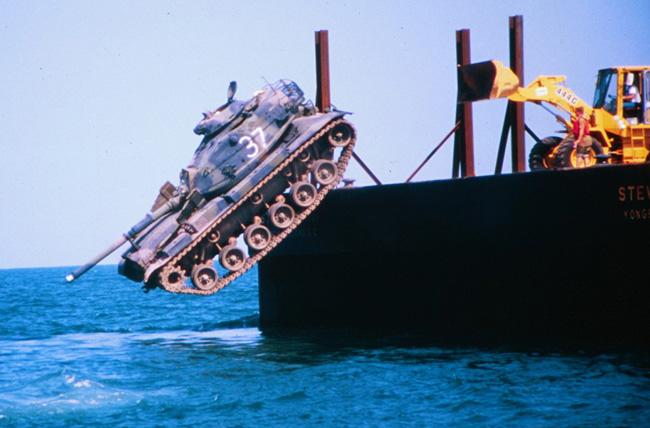
A battle tank is pushed into the ocean to form part of an artificial reef. Photo credit: Georgia DNR.
Over the past 50 years, the state has placed hard-surface materials in 18 sites, each about 15 square kilometers in size. Eight of the sites are located along the coast approximately 10 miles off shore and another eight approximately 25 miles off shore. There are also two “beach reefs” that are closer to shore and accessible to fishermen with smaller boats. The reefs are made up of a wide range of materials, including old ships, battle tanks, pieces from the original Talmadge Bridge, retired subway cars from New York City, concrete pipes and pilings, and purpose-built, concrete tetrapods.
“The materials that were placed on the bottom in the 1970s and 1980s were sunk in place or deployed from barges using Loran-C, a radio-based navigation system that was significantly less accurate than current GPS, or dropped from Army helicopters, so their precise locations are not always exactly known,” Alexander said. “In addition, we have had a number of hurricanes and winter storms come through or offshore Georgia, and we don’t know whether some of the material has been moved from its original location.”
Alexander proposed a program to survey the reefs and develop a more accurate set of data on their locations and characteristics, which was subsequently funded through the Georgia Coastal Management Program, administered by the Georgia Department of Natural Resources Coastal Resources Division.
Marine life attracted to one of Georgia’s artificial reefs. Photo credit: Georgia DNR.
“Our goals were to document the status of what is on the bottom, and to give more precise locations for the objects we identify,” Alexander said. “We used real-time kinematic GPS, so we know within a few centimeters where things are on the bottom.”
Alexander’s team began field work in 2018 and continued into 2021, using the 28-foot RV Jack Blanton. They spent an average of six days surveying each reef. They started with the beach reefs to work out any kinks in the planned survey approach and then moved on to the reefs 10 miles off shore. Along with high-resolution GPS, the team used an interferometric side-scan sonar that gives the depth and co-registered side-scan sonar imagery that provides images of the seafloor and objects sitting on it.
“Based on an object’s general location, and existing location data, we were able to make some good guesses as to ‘Oh, that must be a certain barge or ship’ and so on,” he said. “And we found a few objects that were not on existing maps and several others that had fragmented into several pieces since being placed.”
Another important parameter the team measured was the amount of clearance between the various structures and the ocean surface.
“You don’t want to have to worry about anything you put down being a hazard to navigation,” Alexander said. “Ten kilometers off shore, you are in about 10 meters of water or so, about 30 feet. So, if one of these sunken vessels was sticking up a significant height above the bottom, that is something you need to know.”
Alexander and DNR are making plans to survey the eight reefs that are about 25 miles off shore. They present a greater challenge than the reefs closer to shore. The longer distance means greater transit time and less time on-station actually conducting the survey. The team would also be constrained by the weather. Conditions must be very good and forecast to remain calm throughout both the transits and survey.
“Because when you are that far offshore, you are at the mercy of sea conditions, which can change quickly” Alexander said.
The data Alexander’s team collected is now being added to the DNR’s marine artificial reef fishing website. These new data products enhance the data available to anglers, and now allows users to zoom in to the individual features, see what they look like, and how they are distributed in relation to other features on the bottom. The data collected by the project can be found on the DNR’s artificial reef website:https://coastalgadnr.org/HERU/offshore