Tag Archives: DNR

Cutting edge survey charts Georgia’s artificial reefs

– Beginning in 1970, the Georgia Department of Natural Resources built a series of artificial reefs to provide habitat for marine life. However, until recently, there were gaps in some of the key information about those reefs, such as the precise locations of the materials placed on the bottom and water depth over the materials. Now, researchers at the University of Georgia Skidaway Institute of Oceanography are using cutting-edge bathymetric side-scan sonar and high-resolution geographic positioning systems (GPS) to provide coastal managers and fishermen a detailed picture of the location and condition of reef materials.

Georgia’s shelf is relatively shallow and extends approximately 80 miles offshore before dropping into the deep ocean. Most of the shelf bottom consists of shifting sand, which does not provide the kind of conditions to develop and support diverse reef communities.

“Much of the continental shelf is like a vast sandy desert,” UGA Skidaway Institute scientist Clark Alexander said. “So, what we need is more hard substrate, because that is really the most important thing for establishing stable live-bottom communities.”

A battle tank is pushed into the ocean to form part of an artificial reef. Photo credit: Georgia DNR.

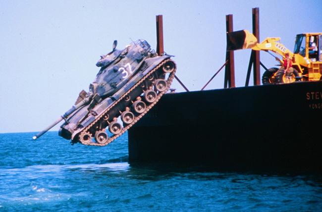
Over the past 50 years, the state has placed hard-surface materials in 18 sites, each about 15 square kilometers in size. Eight of the sites are located along the coast approximately 10 miles off shore and another eight approximately 25 miles off shore. There are also two “beach reefs” that are closer to shore and accessible to fishermen with smaller boats. The reefs are made up of a wide range of materials, including old ships, battle tanks, pieces from the original Talmadge Bridge, retired subway cars from New York City, concrete pipes and pilings, and purpose-built, concrete tetrapods.

“The materials that were placed on the bottom in the 1970s and 1980s were sunk in place or deployed from barges using Loran-C, a radio-based navigation system that was significantly less accurate than current GPS, or dropped from Army helicopters, so their precise locations are not always exactly known,” Alexander said. “In addition, we have had a number of hurricanes and winter storms come through or offshore Georgia, and we don’t know whether some of the material has been moved from its original location.”

Alexander proposed a program to survey the reefs and develop a more accurate set of data on their locations and characteristics, which was subsequently funded through the Georgia Coastal Management Program, administered by the Georgia Department of Natural Resources Coastal Resources Division.

Marine life attracted to one of Georgia’s artificial reefs. Photo credit: Georgia DNR.

“Our goals were to document the status of what is on the bottom, and to give more precise locations for the objects we identify,” Alexander said. “We used real-time kinematic GPS, so we know within a few centimeters where things are on the bottom.”

Alexander’s team began field work in 2018 and continued into 2021, using the 28-foot RV Jack Blanton. They spent an average of six days surveying each reef. They started with the beach reefs to work out any kinks in the planned survey approach and then moved on to the reefs 10 miles off shore. Along with high-resolution GPS, the team used an interferometric side-scan sonar that gives the depth and co-registered side-scan sonar imagery that provides images of the seafloor and objects sitting on it.

“Based on an object’s general location, and existing location data, we were able to make some good guesses as to ‘Oh, that must be a certain barge or ship’ and so on,” he said. “And we found a few objects that were not on existing maps and several others that had fragmented into several pieces since being placed.”

Another important parameter the team measured was the amount of clearance between the various structures and the ocean surface.

“You don’t want to have to worry about anything you put down being a hazard to navigation,” Alexander said. “Ten kilometers off shore, you are in about 10 meters of water or so, about 30 feet. So, if one of these sunken vessels was sticking up a significant height above the bottom, that is something you need to know.”

Alexander and DNR are making plans to survey the eight reefs that are about 25 miles off shore. They present a greater challenge than the reefs closer to shore. The longer distance means greater transit time and less time on-station actually conducting the survey. The team would also be constrained by the weather. Conditions must be very good and forecast to remain calm throughout both the transits and survey.

“Because when you are that far offshore, you are at the mercy of sea conditions, which can change quickly” Alexander said.

The data Alexander’s team collected is now being added to the DNR’s marine artificial reef fishing website. These new data products enhance the data available to anglers, and now allows users to zoom in to the individual features, see what they look like, and how they are distributed in relation to other features on the bottom. The data collected by the project can be found on the DNR’s artificial reef website: https://coastalgadnr.org/HERU/offshore

Fall black gill cruise rolls out new smartphone app for better data collection

The University of Georgia Skidaway Institute of Oceanography entered the fourth year of its black gill research program with a daylong cruise on board the Research Vessel Savannah and the introduction of a new smartphone app that will allow shrimpers to help scientists collect data on the problem.

Led by UGA scientists Marc Frischer, Richard Lee, Kyle Johnsen and Jeb Byers, the black gill study is being conducted in partnership with UGA Marine Extension and Georgia Sea Grant, and is funded by Georgia Sea Grant.

Black gill is a condition Georgia shrimpers first noticed in the mid-1990s. Many shrimpers have blamed black gill for poor shrimp harvests in recent years, but until Frischer began his study, almost nothing was known about the condition. Now the researchers know black gill is caused by a parasite—a single-cell animal called a ciliate—although the exact type of ciliate is still a mystery.

The October cruise had three goals. The first was simply to collect data and live shrimp for additional experiments.

“We were able to collect enough live shrimp in good shape to set up our next experiment,” Frischer said. “We are planning on running another direct mortality study to investigate the relationship between temperature and black gill mortality. This time, instead of comparing ambient temperature to cooler temperatures as we did last spring and summer, we will investigate the effects of warming.”

Researchers Marc Frischer (UGA Skidaway Institute), Brian Fluech and Lisa Gentit (both UGA Marine Extension and Georgia Sea Grant) examine shrimp for signs of black gill.

Researchers Marc Frischer (UGA Skidaway Institute), Brian Fluech and Lisa Gentit (both UGA Marine Extension and Georgia Sea Grant) examine shrimp for signs of black gill.

If his hypothesis is correct, Frischer believes researchers would expect that raising fall water temperatures to warmer summer levels in a laboratory setting will induce black gill associated mortality in the shrimp caught in the fall.

Those studies will be compared to those that are being conducted in South Carolina in a slightly different manner. Frischer expects the results should be similar.

“However, as it goes with research, we are expecting surprises,” Frischer continued. “We also collected a good set of samples that will contribute to our understanding of the distribution and impact of black gill.”

A second goal was to introduce and begin field testing a new smartphone application developed by Johnsen. The app is intended to be a tool that will allow shrimp boat captains and recreational shrimpers to assist the researchers by filling some of the holes in the data by documenting the extent of black gill throughout the shrimp season. The Georgia Department of Natural Resources conducts surveys of the shrimp population up and down the coast throughout the year. However, those surveys do not provide the researchers with the rich data set they need to really get an accurate assessment of the black gill problem.

A screenshot of the smartphone app for tracking black gill.

A screenshot of the smartphone app for tracking black gill.

“Instead of having just one boat surveying the prevalence of black gill, imagine if we had a dozen, or 50 or a hundred boats all working with us,” Frischer said. “That’s the idea behind this app.”

The fishermen will use the app to document their trawls and report their data to a central database. Using GPS and the camera on their smartphone, they will record the location and images of the shrimp catch, allowing the researchers to see what the shrimpers see. If repeated by many shrimpers throughout the shrimping season, the information would give scientists a much more detailed picture of the prevalence and distribution of black gill.

“The app is complete and available on the app store, but we are still in the testing stages,” Johnsen said. “We want to make sure that it will be robust and as easy to use on a ship as possible before widely deploying it.”

Recruiting, training and coordinating the shrimpers will be the responsibility of UGA Marine Extension and Georgia Sea Grant.

“I think it should be entirely possible to at least have a small group of captains comfortable and ready to start using it when the 2017 season begins,” Frischer said.

Johnsen is excited about the app for what it can provide to the shrimping and research community, but also the implications it has for using apps to involve communities in general.

“There is still work to be done to improve the usability of these systems,” he said. “But I’m confident that we are going to see an increasing number of these ‘citizen science’ applications going forward.”

The final aim of the cruise was to bring together diverse stakeholders, including fishery managers, shrimpers and scientists, to spend the day together and share ideas.

“This was a good venue for promoting cross-talk among the stakeholder groups,” Frischer said. “I had many good conversations and appreciated the opportunity to provide a few more research updates.”

Frischer says he thinks the communication and cooperation among the various stakeholder groups has improved dramatically since the beginning of the study. He recalled that when the study began in 2013, tensions were high. Shrimpers were angry and demanded that something be done to address the problem of black gill. Meanwhile, fishery managers were unclear if black gill was even causing a problem and frustrated that no one could provide them any reliable scientific advice. The research community had not been engaged and given the resources to pursue valid investigations.

“In 2016, we still have black gill. The fishery is still in trouble, but it does feel like we are at least understanding a bit more about the issue,” Frischer said. “Most importantly, it is clear that all of us are now working together.

“My feeling is that the opportunity for us to spend a day like that together helps promote understanding, communication and trust among the shrimpers, managers and researchers.”

Shrimpers, others join UGA Skidaway Institute Black Gill research cruise

UGA Skidaway Institute of Oceanography scientists are studying a condition in shrimp found along the Southeast Coast known as Black Gill. As part of this effort, a group that included UGA Skidaway Institute scientists and representatives from Georgia Sea Grant, UGA Marine Extension, Georgia DNR, the shrimping industry and researchers from North and South Carolina joined a one-day research cruise on board the R/V Savannah on October 9. The focus of the cruise was to collect shrimp for the Black Gill research project, and also to give the various groups the opportunity to exchange ideas. This account of the project comes from UGA Skidaway Institute scientist and cruise-organizer Marc Frischer.

We had 20 people on board (not including the ship’s crew), representing three states (Ga. S.C. and N.C.) and interests from the industry, management, research, and education/outreach communities. Although sometimes the conversations were outside of my comfort zone, I found the discussions and interactions that I had interesting, significant and useful. I found particularly interesting the perspectives from some of the professional shrimpers who were onboard made it clear to me that a research priority should be investigating the relationship between shrimp mortality in the field and the incidence of Black Gill. Discussions with the management community also provided me new insights into the difficulties we are facing with management and regulation. Conversations with those charged with communicating with the broader public remind me to choose words carefully to avoid misunderstanding.

A shrimp with the Black Gill condition clearly evident.

A shrimp with the Black Gill condition clearly evident.

In terms of the science, the day was largely successful despite the very low shrimp catches. Our priority was to collect enough live shrimp to conduct experiments to investigate black gill transmission and to explore the effect of ciliate infection on molting frequency. Although there were not many shrimp caught, we caught enough to conduct our planned experiments, and we were able to bring live shrimp into our facilities with almost no mortality. Utilizing the relatively large R/V Savannah and being able to dock within feet of our labs made this possible.

Skidaway Institute professor Marc Frischer examining a shrimp.

Skidaway Institute professor Marc Frischer examining a shrimp.

Thanks goes to the director of the Skidaway Institute of Oceanography (Jim Sanders) for making the vessel available to us. Cost for the ship is not covered by funding provided by Georgia Sea Grant and was provided as matching funds by the Institute.

Experiments got underway immediately upon our return and will continue for the next several weeks. If anyone is interested and wants to visit the lab for an update you are welcome to do so.

DNR's Pat Geer and Sea Grant's Jill Gambill sort through the marine life caught in a trawl.

DNR’s Pat Geer and Sea Grant’s Jill Gambill sort through the marine life caught in a trawl.

In addition to collecting live specimens, we were able to collect and preserve samples for a large variety of other analyses that will contribute to our identification of the Black Gill agent and to understanding its impact on shrimp. Several of the samples we collected are now on their way to various labs around the world where researchers with expertise beyond ours will study them.

Also, for the first time, we, collected water and sediments to be examined using our novel molecular-based diagnostic tools that are just now coming online. These studies will form the basis of a student project and thus generate both new information and new talent.

The team from the October Black Gill cruise.

The team from the October Black Gill cruise.

Unfortunately, because we were not able to catch more shrimp, we were not able to quantify the prevalence of Black Gill along the transect we sampled (offshore Wassaw Island, Wassaw Sound, and the Wilmington and Skidaway Rivers). However, this is a task valiantly undertaken by the GA DNR who had just visited the area in September and will be at it again. However, in addition to observing that catches were low everywhere, we were able to estimate a prevalence in the neighborhood of 50 percent. Except for offshore where we only caught one shrimp and it had black gill (so 100 percent). Two insights from this experience — first, our observations agree very well with DNR’s estimates and it is clear that we are probably not sampling sufficiently. Second — engaging the fishing community in this effort, if we can do so in a scientifically sound manner, will be truly helpful.