By Nadine Slimak and Michael Sullivan
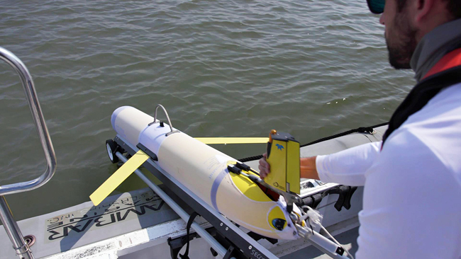
When the Slocum glider known as NG645 was deployed about 80 miles south of New Orleans on Oct. 10, 2021, it became one of the most closely watched ocean-observing instruments in the Gulf of Mexico. That’s because it was a small robot with a big mission – to investigate features of the Loop Current and Loop Current Eddies in the Gulf as part of the Hurricane Glider Project – then navigate on a mission never attempted by an unmanned glider before.
“Our goal with this project was to deploy a glider in the Gulf of Mexico and then navigate it through the spatially variable currents of the Loop Current and into the Gulf Stream all the way around the bend of Florida up to the coast of South Carolina,” said UGA Skidaway Institute of Oceanography researcher Catherine Edwards, one of the glider team leaders and who was responsible for the glider once it rounded the tip of Florida.
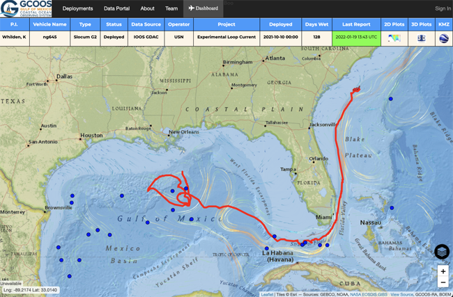
The trip was a test to see whether the glider could successfully navigate around Florida and up the East Coast while gaining information about multiple marine systems – all during a single mission. With no propeller or motor, it would have to do so using minimal battery power and only buoyancy to travel.
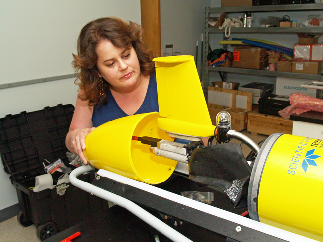
Slocum gliders, also known as autonomous underwater vehicles (AUVs), are torpedo-shaped underwater robots about six feet long and eight inches in diameter that carry instrument packages to gather data on water temperature, salinity, dissolved oxygen and other ocean parameters, depending on ocean-observation needs. The gliders use buoyancy to move throughout the water column in a vertical yo-yo pattern, taking in water to move down through the water column and expelling water to return to the surface. The wings on the glider then give it lift that allows it to move forward. When the glider surfaces, it sends data to a satellite, which beams it back to scientists in the lab. Back in the laboratory, glider pilots can update and adjust glider trajectories to ensure they remain on course, or even change their paths.
NG645’s initial mission was to gather information on the Loop Current and Loop Current Eddies, major oceanographic features in the Gulf of Mexico.
“The Loop Current is sort of an arm of the western boundary current that eventually becomes the Gulf Stream,” Edwards said. “That’s one of the major features that this project seeks to capture. Just like we’re monitoring the edge of the Gulf Stream with our gliders, these are areas where the models need the most improvement, and where our observations can have the greatest impact.”

The glider was a part of the Hurricane Glider Project, a series of gliders monitoring the ocean in the Gulf, Caribbean Sea and Atlantic that are programmed to collect information on ocean parameters from areas where tropical storms and hurricanes typically form or strengthen. Gliders gather temperature and salinity readings from throughout the water column, not just at the surface, and send it back to the National Oceanic and Atmospheric Administration in near-real time to improve the accuracy of upper ocean models used to create hurricane intensity forecasts. This was the first-time glider operators attempted such an ambitious mission.
“There were so many firsts during this mission,” said Kerri Whilden, a researcher from Texas A&M University, who led the collaboration in the Gulf before handing it off to Edwards as it rounded Key West and navigated up the East Coast. “It would be the first time we started piloting a glider in the Gulf and then sent it through the Gulf Stream around the tip of Florida, then on to South Carolina. It involved coordinating a lot of different organizations to deploy the glider, to pilot it and then to retrieve it at the end of its mission. It was a big team collaboration for sure.”
In addition to UGA Skidaway Institute and Texas A&M, other partners in the project included the Naval Oceanographic Office, the U.S. Integrated Ocean Observing System, the Gulf of Mexico Coastal Ocean Observing System, the Southeast Coastal Ocean Observing Regional Association, the Underwater Glider User Group, the University of Southern Mississippi, NOAA’s Atlantic Oceanographic and Meteorological Laboratory and the Woods Hole Oceanographic Institute.
Planning is under way for a repeat mission in 2022.


 Edwards is a physical oceanographer, with broad interdisciplinary interests in marine sciences and engineering. She earned a B.S. in physics with highest honors from the University of North Carolina at Chapel Hill, and worked as an ocean modeler at the U.S. Naval Research Laboratory before earning her Ph.D. in physical oceanography from the University of North Carolina at Chapel Hill. She joined Skidaway Institute in 2010.
 UGA Skidaway Institute of Oceanography graduate student Kun Ma has received $25,000 in research funding as part of the Georgia Sea Grant Research Traineeship Program. Ma will use the funds to support her work studying microplastic pollution in Georgia’s marine ecosystem. The project is titled “Determining photodegradation rates and products of textile-derived plastic microfibers in aqueous environments.”
 The administrative assistant and manager of the UGA Marine Education Center and Aquarium, Genell Gibson, received a Staff Award for Excellence on April 1 at the university’s 28th annual Public Service and Outreach Meeting and Awards Luncheon. Gibson was one of eight faculty and staff members recognized for outstanding service to the state and UGA.