Category Archives: Uncategorized

Two UGA Skidaway Institute grad students receive master’s degrees

Two graduate students who conducted their research at UGA Skidaway Institute of Oceanography successfully defended their theses this fall and received their master’s degrees in December.

OLYMPUS DIGITAL CAMERA

Christine Burns (l) and Tina Walters

Tina Walters is a full-time laboratory manager for Skidaway Institute researcher Marc Frischer, and has been attending graduate school at Savannah State University on a part-time basis for several years. Her thesis, is titled “Molecular gut profiling of Dolioletta gegenbauri in the South Atlantic Bight continental shelf: What are they eating?” A chapter of the paper will be published in the journal, “Molecular Ecology, Special issue: Species Interactions, Ecological Networks and Community Dynamics.”

“The overall focus of my research was to determine the role of doliolids in the food web,” Walters said. “What do doliolids eat, and who eats them? My thesis focused on what they are eating out there in nature. I used DNA-based methods to answer that question.”

Walters earned an undergraduate degree in chemistry with a minor in physics from Armstrong Atlantic State University (now Georgia Southern University). She landed an internship at Skidaway Institute during her senior year and stayed on as a research technician after graduation.

Walters credits her advisor, Marc Frischer, for encouraging her on her journey.

“Dr. Frischer always encouraged me to pursue a master’s degree, especially with having the experience of being a lab technician,” she said. “It was time for me to start thinking like a scientist and further understand why the research that we are conducting is so important.”

Walters was also advised by former UGA Skidaway Institute professor Jens Nejstgaard, and professor Carol Pride, chair of the Department of Marine and Environmental Sciences at Savannah State University.

Christine Burns is a graduate student in the UGA Department of Marine Sciences. Her thesis is titled “Historical analysis of 70 years of salt marsh change at three LTER sites.”

“I am using historical aerial imagery and charts to measure long-term changes in the saltmarsh,” Burns said. “Specifically, I’m looking at changes in the area and location of channels, ponds, interior mud flats and upland islands.

“This lets us know how these different marshes change over time and helps us to better understand how stressors such as human modifications and sea level rise influence these really important ecosystems.”

Burns studied sites that are part of the Long Term Ecological Research Network, spanning a range from Georgia to Massachusetts.

“I really enjoy mapping and using GIS,” Burns said. “This project takes my background and interest in salt marshes and pairs it with my love of maps.”

From Skidaway Island, Burns will head to Washington, D.C. She has been selected for a prestigious Knauss Fellowship and will work in the NOAA Office of Coast Survey as the Precision Navigation Fellow.

Burns was advised by UGA Skidaway Institute director Clark Alexander and UGA Department of Marine Sciences professor Merryl Alber, who is also the director of the UGA Marine Institute on Sapelo Island.

UGA Skidaway Institute scientist visits China

UGA Skidaway Institute researcher Julia Diaz recently returned from a visit to Nankai University in Tianjin, China, where she gave a guest lecture and an invited talk.

Julia China 1 650p

Julia Diaz at Nankai University

Diaz was invited by a Nankai University faculty member who had been a colleague of hers when they were both post-docs at Woods Hole Oceanographic Institution.

“It was my first time in China,” Diaz said. “I didn’t know what to expect.”

She visited Beijing and the Great Wall of China.

“I was surprised how few people speak English there,” she said. “My friend set me up with a tour guide, so I had my babysitter. She told me what to eat, where to go, how to dress, everything.”

Diaz said that teaching the class was a challenge because of the language difference. She presented in English, and, while most of the students knew some conversational English, specialized technical terms presented a difficulty.

She delivered a guest lecture on “The global phosphorus cycle” and an invited talk on “Marine polyphosphate: linking the global phosphorus cycle over modern and geologic timescales.”

“It was a challenge, but a very interesting experience,” she said. “I learned a lot and will probably go back again.”

Glider partners come to the rescue during Hurricane Irma

Hurricane Irma presented an interesting problem to UGA Skidaway Institute scientist Catherine Edwards and other glider operators in the Southeast. They had several autonomous underwater vehicles or “gliders” deployed off the east coast as the hurricane approached, including Skidaway Institute’s glider, “Modena.” Edwards and the others were confident the gliders themselves would be safe in the water, but the computer servers that control them would not.

Catherine Edwards works on “Modena.”

The gliders are equipped with satellite phones. Periodically, they call their home server, download data and receive instructions for their next operation. It was expected that Skidaway Institute would lose power for at least several days (as did happen). However, Skidaway’s backup server partner at the University of South Florida’s marine science facility in St. Petersburg, Fla. was also directly in the storm’s projected path.

“In the week before she hit, Irma sort of blew up our hurricane emergency plans,” Edwards said.

Several other options, including Teledyne Webb’s back-up servers and Rutgers University were not feasible for technical reasons. Glider operators at Texas A&M University came to the rescue. Catherine was able to instruct “Modena” to switch its calls over the Texas A&M server. No data was lost and “Modena” continued its mission.

According to Edwards, two big lessons emerged from the experience.

“First, most of us rely on nearby or regional partners for emergency and backup support, but disasters are regional by nature, and the same Nor’easter or hurricane can take you down along with your backup,” she said. “Second, there aren’t a lot of glider centers that can absorb several gliders on a day’s notice, and there are some compatibility and operations issues involved, so it is best to identify our potential partners and build out these steps into our emergency plans well in advance.”

Skidaway Institute graduate students participate on a glider team cruise off Cape Hatteras

Skidaway Institute graduate students Kun Ma and Lixin Zhu recently joined a science cruise on the Research Vessel Savannah off Cape Hatteras, North Carolina. The cruise, which ran from May 31-June 5, was led by Jeffrey Book from the U.S. Naval Research Laboratory. The main objective of this cruise was to test and demonstrate the use of gliders together in teams and to assimilate the data into ocean forecast models. The cruise was 22 days in total, divided into three legs. Ma and Zhu were part of the third leg.

Kun Ma cocking the Niskin bottles on a Conductivity-Temperature-Depth array.

Ma is a new University of Georgia doctoral student at Skidway, working mainly on a National Science Foundation-funded photochemistry project with professors Jay Brandes and Aron Stubbins. This was her first science cruise and she collected some particulate organic matter and dissolved inorganic carbon samples. She also helped Skidaway Institute researcher Bill Savidge by collecting some chlorophyll samples in order to calibrate the chlorophyll sensor on the CTD instrument, an instrument used to collect water samples and measure those samples’ properties, such as Conductivity (a proxy for salinity), Temperature and Depth.

Lixin Zhu in immersion suit during safety trainning

Zhu is a visiting doctoral student in Aron Stubbins’s lab from East China Normal University. He collected filtered water samples on the cruise. Zhu will analyze the color and fluorescence of dissolved organic matter, and dissolved black carbon concentrations. In addition, Zhu performed solid phase extraction and collected high-resolution real-time data on colored organic matter with the underway scientific computer system on the ship. Eventually, he will combine these data with other field data collected in the South Atlantic Bight area to see the overall dynamics of dissolved black carbon.

“I am glad that we overcame seasickness, and it’s really cool to see that the glider team controlled six gliders at the same time aboard,” Zhu said. “Furthermore, their working approach and decision making process, based on real-time data, modeling and satellite results, impressed me a lot.”

Savannah Science Seminar students learn about Skidaway Institute research

A group of local high school students got an up-close look at oceanography through a special program at UGA’s Skidaway Institute of Oceanography. The students were participants in the Savannah Science Seminar, a nine-month-long program designed to promote an understanding and appreciation for science through informative, participatory presentations and hands-on workshops in the fields of engineering, technology, mathematics and medicine.

Julia Diaz profiles some of her research.

Their March 27 visit to Skidaway Institute exposed them to some of the topics studied and techniques used in marine research.

Skidaway Institute scientist Julia Diaz organized the evening’s program. After an introductory talk by researcher Jim Sanders, the students were split into three groups that rotated among three science stations.

Physical oceanographer Catherine Edwards explained the workings of autonomous underwater vehicles.

Catherine Edwards describes an AUV.

Graduate students Patrick Duffy and Sean Anderson demonstrated the new LIME imaging lab.

Patrick Duffy (2nd from right) and Sean Anderson (far right) introduce the students to cutting edge microbial imaging instruments.

Diaz and grad student Sydney Plummer discussed eutrophication and phytoplankton blooms.

Symposium highlights UGA Marine Extension and Georgia Sea Grant impacts

When Hurricane Matthew hit the Georgia coast last October washing away some of its sandy shoreline, UGA was ready.

With funding from Georgia Sea Grant, the UGA Skidaway Institute of Oceanography already was studying sand resources and creating an inventory of sand deposits along the coast. Researchers are using that inventory to identify areas where sand was available to replenish the coastline that was lost during the storm. Replacing the lost sand is important to protect lives and property, as well as critical habitats, from coastal hazards.

“The sand resources in our state waters are the most poorly known of all the states along the east coast,” said Clark Alexander, interim director of Skidaway Institute. “This research enables us to create maps identifying offshore areas that are suitable for beach nourishment and habitat restoration projects. With these data, we can know where suitable sand exists if we need it in the future after major storms.”

Clark Alexander

Alexander was one of many researchers across Georgia who presented a project during the Marine Extension and Georgia Sea Grant Research Symposium in Athens on June 1. The annual symposium provides an opportunity for researchers to share their Sea Grant-funded work, network with others in the scientific community and look for collaborative ways to tackle the latest issues impacting the coast.

“Case studies presented during the symposium aptly illustrated Georgia Sea Grant’s success in elevating awareness of coastal issues, increasing local communities’ resilience to the effects of a changing climate and developing models that can be replicated to improve conditions on a global scale,” said Paul Wolff, chair of the Marine Extension and Georgia Sea Grant Advisory Board.

Marc Frischer describes research into black gill in shrimp.

From projects that look at how to get local seafood into inland markets to those that measure the productivity of Georgia’s expansive salt marshes, Sea Grant-funded research spans a variety of topics and emphasizes the importance of multidisciplinary, collaborative research and outreach to effectively enhance coastal communities and ecosystems.

Research proposals submitted to Georgia Sea Grant are expected to include an education and outreach component to ensure that results reach beyond the research community and are delivered to a diverse audience.

Jay Brandes presents his research into microplastics on the Georgia coast.

Education and extension faculty and staff at Marine Extension and Georgia Sea Grant work to incorporate Sea Grant-funded research into public programs, workshops and curricula targeted to pre-k through college age students, resource managers, decision makers, the seafood industry and beyond.

“We received a record number of research funding preproposals this year and many of those submitting full proposals attended the research symposium,” said Mark Risse, director of Marine Extension and Georgia Sea Grant. “Being able to learn from projects that have proved successful should strengthen research efforts and allow us to support projects that move rapidly to application and impact.”

Kayla Clark describes the Sea Grant intern program.

Other presenters from the Skidaway Marine Science Campus included UGA Skidaway Institute professors Jay Brandes and Marc Frischer, and from Marine Extension, associate director for marine education Anne Lindsay and public programs coordinator Kayla Clark.

UGA Skidaway Institute researchers probe complex Atlantic Ocean currents

Dana Savidge

The ocean off the coast of North Carolina has a complex system of ocean currents that make it one of the least understood areas on the U.S. Eastern Seaboard. University of Georgia Skidaway Institute of Oceanography professor Dana Savidge is leading a team of scientists, including UGA Skidaway Institute scientist Catherine Edwards, working to unravel the mysteries of the complex ocean currents near Cape Hatteras.

The four-year project, informally called PEACH: Processes driving Exchange At Cape Hatteras, was launched in early 2016 and is funded by a $5 million grant from the National Science Foundation to better understand the relationship between the waters of the continental shelf and the deep ocean.

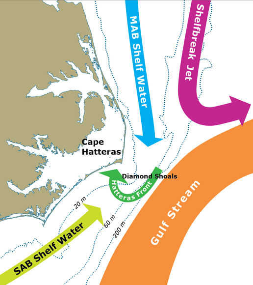
“The U.S. continent, like others, has a shallow ocean immediately around it, called the continental shelf. It’s like an apron that extends out from the shoreline and it is fairly shallow, only about 60 meters deep,” Savidge said. “At its outer edge, the bottom drops sharply into the deep ocean, which can be miles deep.”

Exchange at the shelf edge can push cold, nutrient-rich water from the deep ocean onto the shelf, which drives productivity of marine algae and the food web that it supports.

“There’s a reason people love offshore fishing at the edge of the Gulf Stream,” said Edwards. “Areas with regular exchange of shelf and deep waters are often known hot spots for commercial and recreational fishing.”

One reason Cape Hatteras attracted the researchers’ attention is that two opposing deep ocean currents collide there, making the ocean there highly dynamic. The warm Gulf Stream hugs the edge of the continental shelf as it flows north from the tip of Florida. At Cape Hatteras, the Gulf Stream opposes a colder current, the Slope Sea Gyre current, that moves southward along the mid-Atlantic coast. There, the Gulfstream breaks away from the coast toward northern Europe.

There is a convergence of shelf currents at Cape Hatteras as well, as cool shelf waters of the mid-Atlantic continental shelf meet the warm salty shelf waters from the south. Each of these currents, on the shelf and at the shelf edge, has a distinct temperature, salinity, and often a biological signal that reflects the origin of the water it carries. The team will measure these properties and ocean currents to better understand the exchange processes.

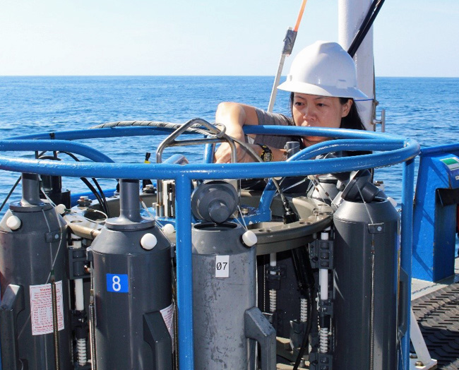
During the first year of the study, the researchers prepared and installed a network of sophisticated, high-tech instruments on the shore and in the ocean to monitor and capture the movement of water and changing properties like temperature and salinity. Together with scientists from the University of North Carolina and North Carolina State University, the team has worked with ocean models to better understand the interaction between shelf currents and the deeper currents of the Gulf Stream and the Slope Sea Gyre.

“Circulation on the continental shelf and the deep ocean can be quite separate things, but their effects on one another can be quite complicated,” Savidge said.
In addition to subsurface packages moored on the sea floor, the PEACH team is taking advantage of modern sampling techniques with shore-based radar systems and autonomous underwater vehicles called gliders to collect data remotely.

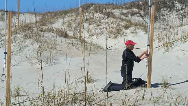
Savidge working on a radar antenna on the Outer banks.

Savidge’s hardware contribution to the project is a series of low-power, high-frequency radar stations that scan the waters of the continental shelf and measure the speed and direction of surface currents.

“Measuring surface currents remotely with the radars is a real advantage here,” Savidge said. “They cover regions that are too shallow for mobile vehicles like ships to operate, while providing detailed information over areas where circulation can change quite dramatically over short times and distances.”

An array of radar antennae on an Outer Banks beach.

Savidge’s research technician, Gabe Matthias, installed the radar systems on the beach at Salvo and Buxton, and at the airports at Frisco and Ocracoke, North Carolina. Currently, the researchers are working out the bugs in the system and getting the four stations to work together to paint a composite picture of the surface currents. The radars produce a massive amount of data to be processed.

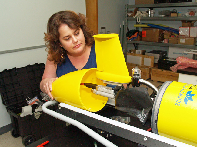
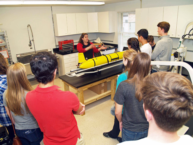
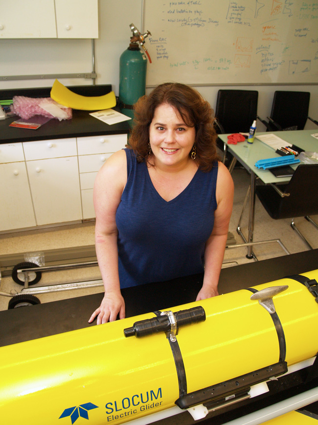
Edwards leads the effort to use gliders that will operate on the shelf for nearly the entire 16-month experiment. Gliders are shaped like torpedoes and equipped with sensors to measure properties like temperature, salinity and dissolved oxygen. They can be programmed to cruise the underwater environment for weeks at a time, surfacing at regular intervals to transmit its collected data via a satellite phone.

Edwards in her lab with a glider.

Edwards’s specialty is improving the way these gliders sample the coastal waters using information from models and real-time data streams, including surface currents from Savidge’s HF radar. Edwards and doctoral students Qiuyang Tao and Mengxue Hou, co-advised by Edwards and Fumin Zhang of Georgia Tech, have developed new systems that optimize the path of the gliders based on near real-time information about current patterns and how they are expected to change, making operations more efficient and allowing better data collection.

“The glider provides data that help explain how temperature, salinity, and density change in space and time underwater, and the HF radar provides high resolution maps of surface currents every 20 minutes,” said Edwards. “The two systems are highly complementary, and their combination provides an unprecedented view of when, where, and why there is exchange between the shelf and deep ocean.”

According to Savidge, the study should produce a greater understanding of the forces at work at Cape Hatteras with implications across a wide range of interests from fisheries management to pollution control. Microscopic marine plants, known as phytoplankton, are a vital part of the marine ecosystem. Phytoplankton are the very base of the marine food web and they produce approximately half the oxygen in the atmosphere. In addition to tracking deep water inputs that support productivity on the shelf, Savidge said, it would is also be important to understand any processes that transport carbon-rich shelf water back to the deep ocean. When phytoplankton and the rest of the food web convert nutrients into their own biomass, water returned to the deep ocean can carry large quantities of organic carbon with it.

The knowledge gathered at Cape Hatteras will be applicable to other oceans around the world.

“Cape Hatteras is the ideal place to look at these processes that you are going to find elsewhere,” Savidge said. “You have a lot of energetic forcing and everything is concentrated in a very small space, with large variations over short distances. The idea is to understand the processes so you can model them effectively. If you can do that, you can anticipate how circulation on the shelf and exchanges with the deep ocean will respond to changes in the Gulf Stream or the wind over time.”

The project will run through March 2020. The other members of the research team are Harvey Seim and John Bane of the University of North Carolina; Ruoying He of North Carolina State University; and Robert Todd, Magdalena Andres and Glen Gawarkiewicz from Woods Hole Oceanographic Institute.

Savidge expressed special appreciation to the National Park Service and the North Carolina Department of Transportation for providing sites for the radar installations, and the University of North Carolina’s Coastal Studies Institute for help in installing them.

Scientists work to predict 22nd century look of the Georgia coast

The Georgia coast is characterized by a complex system of barrier islands, salt marshes, estuaries, tidal creeks and rivers. As the sea level rises over the next century, that picture will change. UGA Skidaway Institute of Oceanography scientist Clark Alexander is working on a project to predict how the coast may look 25, 50 and 100 years from now.

Predictions of sea level rise over the next century vary from the current rate of roughly 30 centimeters—about a foot—to as much as two meters—about 6 feet. Although scientists disagree on the ultimate height of the rise, they all agree that salty water is moving inland and will continue to do so for the foreseeable future, Alexander said. Here on the Georgia coast, islands will become smaller or disappear entirely; salt marshes will be inundated by the rising waters and migrate toward the uplands; and some low-lying uplands will become salt marshes.

To predict the extent of these changes, scientists are using the predictive Sea Level Affecting Marshes Model, or SLAMM, which was originally developed for the U.S. Fish and Wildlife Service.

SLAMM predicts the effects of future sea level rise based on two key inputs: an elevation mapping of the coastal zone and salinity profiles up the rivers and waterways. Salinity and elevation are two key factors that determine the type of plants, and thus habitat, that will be present at any particular location.

“As the sea level rises, the fresh water in rivers will be pushed further upstream,” Alexander said. “The brackish and salty water will also move up, and the salt marshes will expand.”

Funded by a Coastal Incentive Grant from the Georgia Department of Natural Resources Coastal Management Program, Alexander and his team have been studying the five key river systems along the coast and numerous salt marsh estuaries. Salinity along the coast is dominantly affected by river discharge into the estuaries, so the team has been conducting its surveys during both winter—high river flow—and the summer—low river flow—conditions.

“We start at the mouth of a river about an hour before high tide and then we follow that high tide up the river, mapping the surface salinity along the way,” Alexander said. “We find the maximum inshore intrusion of salinity at high tide during a spring tide. That is the location that defines the boundary between the brackish marshes and the freshwater marshes.”

Researcher Mike Robinson prepares the adjusts the salinity sensors, while fellow researcher LeeAnn DeLeo drives the boat.

Researcher Mike Robinson prepares the adjusts the salinity sensors, while fellow researcher LeeAnn DeLeo drives the boat.

In addition to tracking surface salinity, the researchers also stop periodically and measure the salinity throughout the water column to determine if what they measure at the surface is similar to what is present near the bottom. They lower a device that measures the water conductivity (which is related to salinity), temperature and depth from the surface to the bottom. Also equipped with GPS capability, the device automatically captures the location of every water column profile.

Researcher LeeAnn DeLeo lowers a CTD monitor through the water column.

Researcher LeeAnn DeLeo lowers a CTD monitor through the water column.

In many coastal regions, denser, saltier water tends to sink to the bottom and the lighter, fresher water remains near the surface. However, because of the energy produced by Georgia’s wide tidal range, the team found that most of the water on the Georgia coast is well mixed and doesn’t show up as layers.

The second part of the project is to fine-tune existing elevation data. Scientists have an extensive set of elevation information from airplane-mounted Light Detection And Ranging systems. LIDAR is usually very accurate, except in marshes, because it cannot see through the vegetation to the actual ground surface.

“You might be off by 30 centimeters or more, and in a low-lying, flat area like our coastal zone, that can make a big difference in predicting where the water will flood,” Alexander said.

The Skidaway Institute team is working with Georgia Southern University scientist Christine Hladik on a fix. By comparing LIDAR data with the true elevation in a particular area, Hladik observed that the LIDAR error varied according to the type of plants growing there. For example, if the area contained the dense, tall spartina, the error was large and, on average, a consistent number of centimeters. If the region was covered with a different, less-dense-growing salt marsh plant, like short spartina, the error was smaller but also consistent.

“She discovered that if you know what type of vegetation is covering a section of marshland, you can plug in the correction and come back with an accurate measure of the elevation,” Alexander said.

The research team observed the vegetation and measured the true ground level at 400 randomly selected points throughout coastal brackish and salt marshes in Georgia. That information and knowledge of plant types is being used to correct the existing marsh elevations.

The research team will complete one more set of river surveys before the project ends in September. Alexander hopes to obtain continued funding to use this newly acquired elevation and salinity data in a fresh SLAMM model run for the Georgia coast, using all the high-resolution data developed in this project.

“We should be able to look out as much as 100 years in the future and see where the different wetlands will be by then,” he said. “That way we can plan for marsh sustainability, retreat and sea level rise.”

Skidaway Marine Science Day to feature Georgia’s first oyster hatchery

A close-up look at Georgia’s first oyster hatchery will be one of the featured attractions at Skidaway Marine Science Day on Saturday, Oct. 24. The campus-wide open house will be held from noon to 4 p.m. on the University of Georgia’s Skidaway Island campus, located on the north end of the island.

The oyster research team will provide behind-the-scenes tours of the new hatchery, which is a project of the UGA Marine Extension’s Shellfish Laboratory and Georgia Sea Grant, units of UGA Public Service and Outreach. It is hoped the oyster hatchery will make the Georgia oyster industry more durable, contribute to aquaculture diversification and elevate one of Georgia’s best-kept culinary secrets from the backyard roast to the tables of the finest restaurants from Savannah to Atlanta and beyond.

The hatchery tour is just one feature of a lengthy program of activities, displays and tours making the annual event one that attracts thousands of visitors each year.

The UGA Skidaway Institute of Oceanography’s 92-foot ocean-going Research Vessel Savannah will be open for tours and will exhibit science displays.

Tour the Skidaway Institute’s ocean-going Research Vessel Savannah.

Tour the Skidaway Institute’s ocean-going Research Vessel Savannah.

Elsewhere on campus, Skidaway Institute will present a variety of marine science exhibits and hands-on science activities, including the ever-popular Microbe Hunt and Plankton Sink-Off. Skidaway Institute scientists will present a series of short, informal talks and question-and-answer sessions on current scientific and environmental issues.

The UGA Aquarium, operated by UGA Marine Extension, will be open to visitors with no admission fee. Aquarium educators will offer visitors an afternoon full of activities including a hands-on reptile exhibit, behind-the-scenes peeks of the aquarium, fish feedings and microscope investigations.

The Reptile Experience fascinates nature lovers of all ages.

The Reptile Experience fascinates nature lovers of all ages.

A brand new touch tank exhibit will allow guests of all ages to get up close and personal with common coastal invertebrates.

Touch tanks allow visitors to experience sea creatures   up close.

Touch tanks allow visitors to experience sea creatures up close.

Gray’s Reef National Marine Sanctuary will offer visitors the experience of using the tools of the trade. They can explore an underwater reef with a remotely operated vehicle and find out how youth can participate in Savannah’s own MATE ROV competition. ROVs are underwater robots used on NOAA research vessels worldwide and are crucial for data collection in marine environments.

"Fly" an underwater ROV with Gray's Reef.

“Fly” an underwater ROV with Gray’s Reef.

A photo booth will allow visitors to visualize themselves SCUBA diving at Gray’s Reef or in other exotic settingsand will be able to post their pictures on social media.

Along with the campus organizations, Skidaway Marine Science Day will also include displays, demonstrations and activities from a wide range of science, environmental and education groups, such as The Dolphin Project, the Georgia Sea Turtle Center and The Nature Conservancy. Georgia Power will be on hand to provide information on the upcoming wind turbine project planned for the Skidaway Institute campus.

All activities at Skidaway Marine Science Day are free. For additional information, call 912-598-2325, or see http://www.skio.uga.edu.

UGA Skidaway Institute scientists conduct winter 26-hour sampling program

On the weekend of January 24th, a team lead by UGA Skidaway Institute scientist Aron Stubbins conducted the latest “26 Hours on the Marsh” sampling program on the bluff at Groves Creek on the Skidaway Institute campus. The project was designed to investigate how salt marshes function and interact with their surrounding environment—specifically how bacteria consume and process carbon in the marsh. The team collected water samples throughout two complete tidal cycles, during both the day and night.

The outdoor laboratory on the bluff at Groves Creek.

The outdoor laboratory on the bluff at Groves Creek.

Skidaway Institute's Zac Tait, Thais Bittar, Rob Spencer (FSU) and Aron Stubbins prepare for a sample collection.

Skidaway Institute’s Zac Tait, Thais Bittar, Rob Spencer (FSU) and Aron Stubbins prepare for a sample collection.

Zac Tait collects a water sample from a skiff tied to the bank.

Zac Tait collects a water sample from a skiff tied to the bank.

Thais Bittar and Zac Tait begin to process the water sample.

Thais Bittar and Zac Tait begin to process the water sample.

About a dozen scientists and students were involved in the project. “26 Hours on the Marsh” is supported by two grants from the National Science Foundation. The grants total $1.7 million that represent larger, three-year, multi-institutional and multi-disciplinary research projects into salt marsh activity. These projects bring together faculty, students and staff from UGA’s Skidaway Institute, the University of Tennessee, Florida State University and Woods Hole Research Center. UGA Skidaway Institute scientists include principal investigator Jay Brandes; chemical oceanographers Aron Stubbins and Bill Savidge; physical oceanographers Dana Savidge, Catherine Edwards and Jack Blanton; and geologist Clark Alexander.